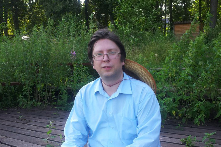
Kirill Bondarenko aka Zkir - software designer and developer of corporate information systems. He has been with OSM for so long that he can safely be called an old-timer of the project, who remembers the black field, the active forum and the creation of the RU-OSM Council. Why then there was more serious talk in the community, why in OSM 3D-models of buildings and where the dreams of the future disappeared - Kirill told about all this in an interview.
- How and when did you hear about OpenStreetMap?
- A long time ago. When computers were large and navigators were not yet so affordable. Most likely, this happened in the late 2000s. But it all started with the fact that I bought a car, and then a navigator. It now has maps of almost any place, then there were big problems with it. Therefore, people for themselves drew the roads on which they drive every day. Even there was such a project as " Draw ". We can say that these are “popular maps” of Navitel and GIS Russes of that time. They were drawn in Polish format in the GPSMapEdit program. I was not a participant in this project, but I began to draw for myself a map of Sergiev Posad.
It is important to note that this process was purely individual: you drew a map for yourself and it was stored on your computer. Therefore, when I more or less drew my city, I began to think about where to place my work, so that others could use it. By today's standards, it was a very simple map for most of the roads. I ended up learning about OpenStreetMap.
- What fascinated you with the mapping process?
- Firstly, then this was of concrete practical benefit: I did it for myself so that I could drive around the city with a navigator. By the way, for some time in the front seat I had a laptop on which the CityGid program was running: she told me where to turn. This is now everyone uses the Yandex.Navigator application, then it was not there. There was a blank card in OSM. It was possible to drive a car, record a track, and then draw a street on it. Now it is difficult to imagine, since almost all the roads in Russia are drawn in OSM.
Secondly, this is a monotonous activity that calms the nerves. If you have an appropriate character warehouse, it can also captivate.
- What was OSM and its community like then? How is it different from our time?
- The Russian community has already been. Moreover, some of its participants are still in it. But overall - it has been seriously updated. A lot of new people. Of the differences? Then the main place of communication was the forum, which I really liked, as it contributed to serious discussions, which are simply impossible in the now fashionable Telegram chat. Therefore, it seems to me that it was at that time that certain foundations were laid and the vector of development was set. We came up with new tags, voted for them, thought more about the project. For example, then the famous Russian classification of roads by importance was developed and adopted.
- Then the community was more serious?
- I would not say that, because the main slogan of OSM: just for fun is to have fun. But then, in addition to this, many serious issues were resolved, the solutions of which we still use. Unfortunately, now I do not observe such activity.
- As far as I know, you were a member of the RU-OSM Council? Tell us about it.
- In my opinion, I am still a member of it. Although, of course, this is a very funny and funny story. How did it start? At one point, Ilya Zverev came into the project and decided to organize this very advice. He had one obsession - to manage everything. I suppose Ilya thought that with the help of the council he would be able to manage a community that does not need this and to a greater extent represents self-government, and quite effective.
Nevertheless, in 2011 we gathered in a restaurant in Moscow and decided to try to create the RU-OSM Council . Created. They held an election in it. There were almost as many candidates as there were seats on this council. Developed regulations. Gathered once a week in IRC chat. We tried to discuss some issues that we considered relevant to the community. Well, what questions can the OSM community have? In general, there’s only one thing - how to tag.
Already now I understand that we all then - both the council members and the osmerias - had overstated expectations. We wanted too much from the RU-OSM Council. People thought that advice for them would do something that they did not want to do.
- For example?
- For example, it somehow organizes the development of some useful tool that was missing. Or understand issues related to data import. Or judge the dispute of two cartographers. We all tried to do this, something even successfully. What else could the advice do? Express an expert opinion on some issue. We joked then that there are no rules in OSM, but only recommendations. Accordingly, the council could make a recommendation, of which there were not so many - only four. One of them is not to use data from the “Public Cadastral Map”. In my opinion, there was still the idea of sorting out issues and preparing material for the OSM Foundation DWG working group , which is involved in rolling back unlicensed edits.
- When you were elected to the RU-OSM Council, what did you dream about? How did the Council position itself? What did he want?
- I think a certain role-playing game is to play king and boyars. But everyone has a different way. It's hard to speak for everyone. My impressions are as follows: I saw that a certain movement was being planned and decided to participate in it no matter what it ended up with. I decided not to pass by what is called.
- And how did it end?
- At some point, it seems to me, people got enough of it, they were tired, first of all, to Ilya Zverev himself, and everything came to naught. I also think that not everyone was ready for the minimal bureaucracy that was required when drawing up the recommendations and decisions of the Council. More and more they wanted to talk and participate in the decision of something, or rather to express their opinion.
The board has not officially been dissolved by anyone; since 2012, it has been operating in the e-mail response mode. Until recently, letters were sent to his address , and they were answered. Now it seems that openstreetmap.ru has set up a mail server.
- Do you continue to draw a map in OSM?
- Not really. The territories that were interesting to me have already been drawn. I'm doing a little different now. I'm trying to raise a project for converting OSM data for one flight simulator. In general, what we dreamed of already happened - OSM was filled with data and they are already using it to the full. So I want to find them another unexpected application.
- Is this somehow related to your interest in 3D modeling in OSM? You therefore made a validator of 3D models ?
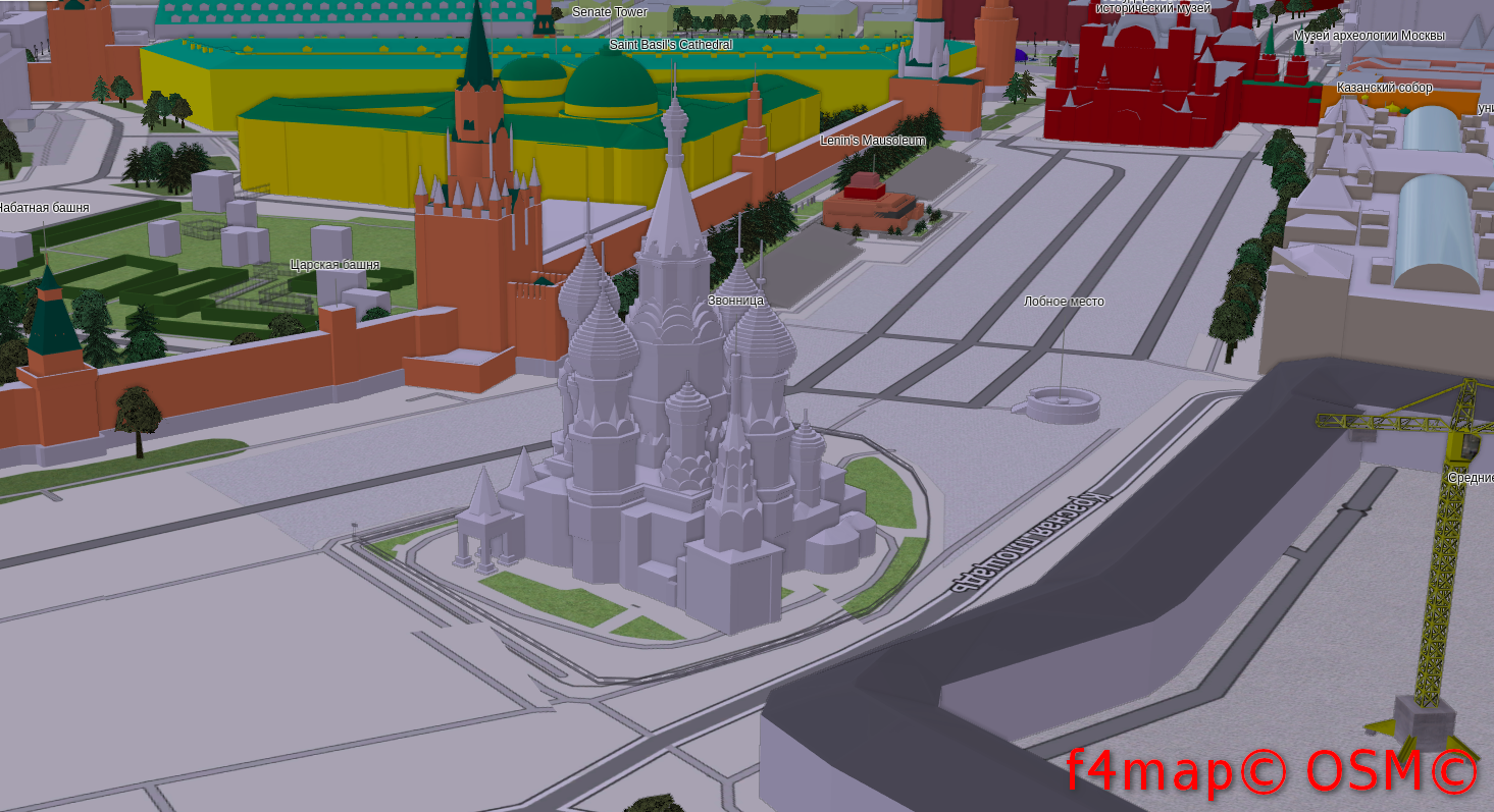
- In part. OSM has grown in width for a long time and continues to do so, and now the time has come for height and volume. From a 3D perspective, OSM is not a plowed field. Look at the St. Basil’s Cathedral in Moscow, which was painted by Felis Pimeja, or at the Trinity-Sergius Lavra and the Nizhny Novgorod Kremlin — I already tried it. I hope this inspires others and they will also take part in this.
- How do you do that? For me it's magic: 3D in OSM. He is flat!
- Oddly enough - it's not difficult. Initially, OSM is a flat map. She thought so. Nevertheless, they came up with a specification called Simple 3D Buildings , which allows you to assemble three-dimensional objects from primitives (primitives in three-dimensional graphics - elementary objects from which more complex ones are assembled - approx. Author), like children's cubes. There is volume. It has a base and height, and the roof has a shape and height. Combining all this you can achieve amazing results.
- How do you draw 3D models? According to the pictures? Or look for ready-made ones?
- Visually, from several photographs in which the object is from different sides. But still, it is desirable to have minimal skills in 3D modeling or drawing. In addition, if it is a known object, you can specify the height. This is all done in the JOSM editor using the kendzi3d plugin, which directly shows a 3D model in it. True, a terribly primitive plugin.
In addition, there is a plugin for Blender that allows you to export to it what is drawn in JOSM to see how it looks. But this is about the same as what you can see on the site of my validator.
- Why do you need to do this in OSM?
“Exactly the same as everything else in OSM.” The first and main reason is just for fun. The second is creative expression. Cards are not a cast of reality, but its comprehension. Why draw a map in OSM? Because almost every Osmer thinks that he will make mankind happy - will bring practical benefits to the world through his edits.
- What are the practical benefits of 3D models in OSM?
- The answer is simple. Why do I need a card? To navigate. What should be drawn on this map? That helps to navigate. Three-dimensional buildings help to navigate? They help. Therefore, they are needed on the map and therefore they need to be drawn. It's one thing when they tell you the address of the building, and another when you immediately see how it looks. It can be assumed that this way you will find it faster.
There is a perspective view in car navigators when they show you a map not from above, but at an angle and in the direction of your movement. Many people choose this particular type. Because there is a horizon, and the road goes to infinity. There are already 3D models of buildings.
You can also do conversions for games. Not so long ago, I recorded a review of the game Generation Street, developed by Roman Shuvalov, in which you fly and shoot against real and recognizable buildings. While 3D in OSM is entertainment, but I think that this direction may also have a future, for example, in urban management.
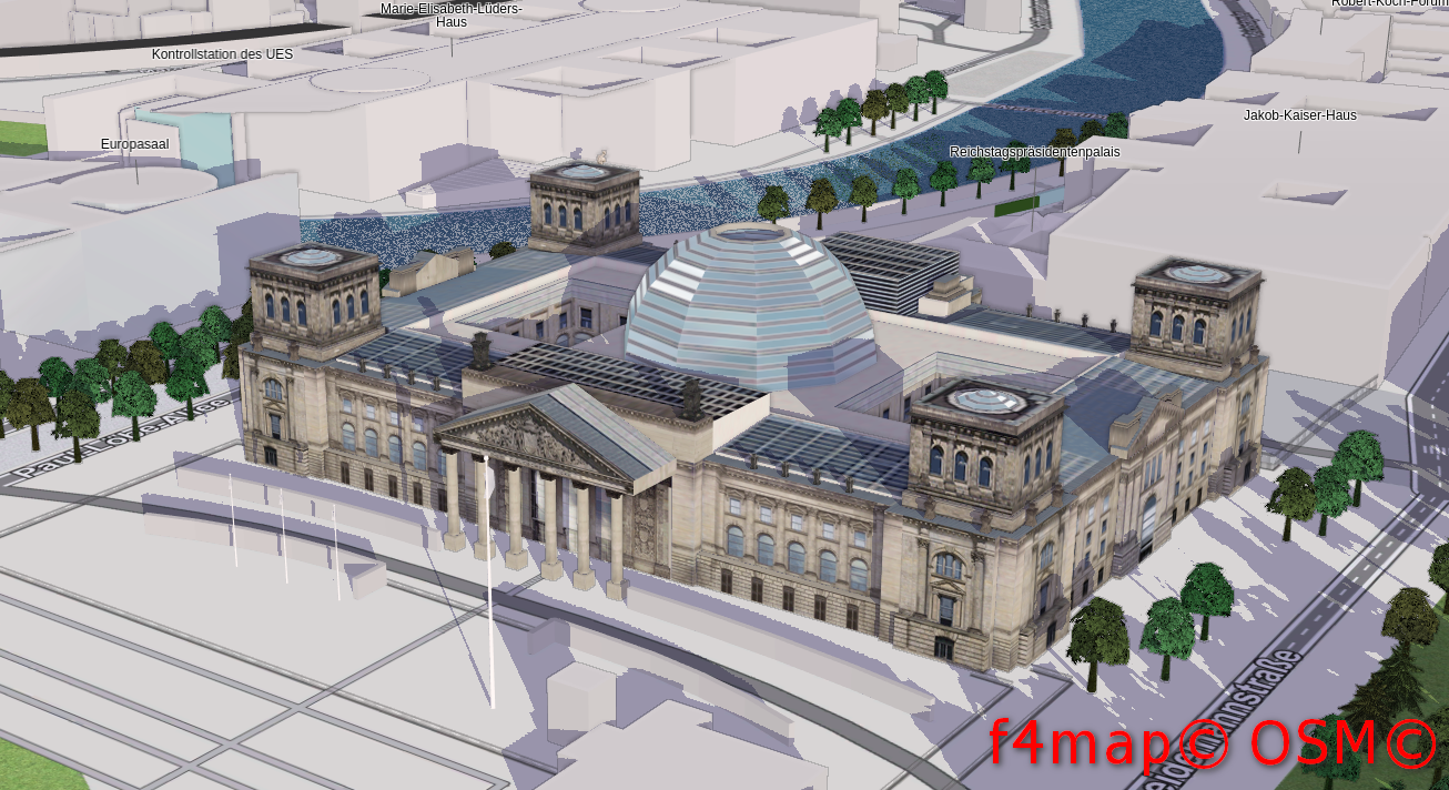
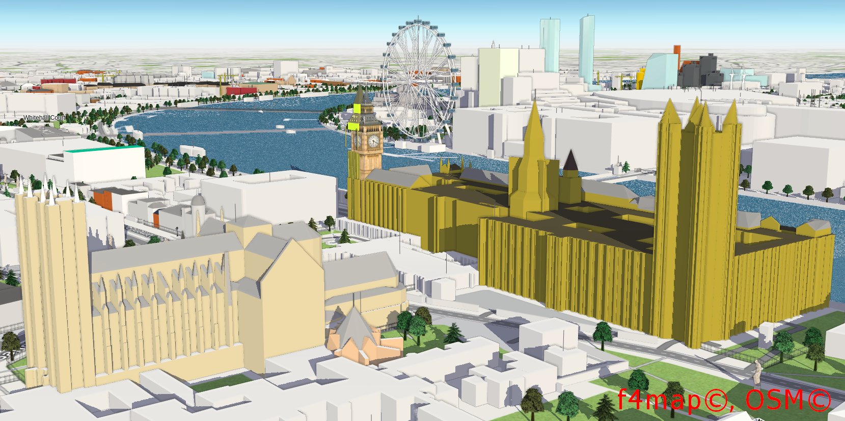
- How common is the drawing of 3D models in OSM in the world? Are there good examples in other countries?
- I did not study this issue. I saw several interesting buildings in Berlin and London . 3D in OSM is only gaining momentum. Somehow I even had an order to create a 3D model in the OSM of an American university. Then they wanted to post it on their website, so that it was easier for students to navigate. Despite the fact that I eventually abandoned this project, I remembered about it in order to show that there is a demand for it.
- Does OSM have a future? Won't large companies absorb or push it in?
- This is a good question. At the moment, OSM is the only project in the world that freely provides such a variety of geodata. You can not only look at the map - tiles, but also take the data itself, on the basis of which the map is made, and make something of your own from them. If someone does this - shares the data for free, then he can push OSM. But I'm not sure that this will happen in the foreseeable future.
In the meantime, we see that new services are constantly emerging around OSM. What are the OSMAnd and Maps.Me navigation applications that use OSM data? They are quite popular now. I’ll dream, if in OSM there will be more 3D-models of buildings, then they will start taking them from there. OSM will be relevant as long as new data is introduced into it.
On the other hand, Google and Yandex tightly linked the search and the map. Looking for curtains, and they show you where to buy them, and even near the house. OSM is behind in this regard. The site osm.org is not developing in any way, like openstreetmap.ru. It seems to me that this is bad. It would be worthwhile to do something newer and more interesting.
- You noted that earlier you and the community as a whole dreamed about something in OSM. Now, as I understand it, no one is dreaming of anything. When and why did dreams leave?
- A year in 2015. You can’t live by expectations all the time. The project had several stages of development. The first is when there was nothing at all. There was a black field and its founder - Steve Coast - put the first point. It was an open world stage. Then, when the OSM was more or less mediocre filled with data: roads appeared, drew all cities, administrative borders, etc., we thought that it was cool and absolutely everyone in the world should use it. But of course this did not happen. No one shared our joy. Then the dreams ended.
But OSM still makes its way and finds its niche. Please OSMAnd, which at the beginning was extremely primitive. It still remains a product of the programming mind, which scares the average user, because the basis of its interface is a completely different paradigm. But this application exists and develops. They use it. There are fans.
The history of OSM is exactly the same as everything else open source. Take Linux. When will everyone switch to it? When will he take over the world? Never. Well, or until it becomes as simple and understandable as Windows or MacOS.
- What do you like about OSM? What do not like?
- I like openness. In “Draw” there are also many who painted what. But all your labors went to your uncle, they did not become yours. The same thing is happening now in People’s Yandex.Maps. I also like the OSM community. You can always chat with like-minded people. Something like a special party for introverts.
I do not like the fact that tags are meaningless. Tags begin to be used sooner than their value is clearly defined and registered on the wiki. As a result, there are tags, but what they mean is unknown. In addition, I do not like the fact that communication has moved from the forum to Telegram chat. On the forum, you can discuss each topic separately, carefully read the topic and the answers to it before writing anything. In the chat, discussing serious things is impossible in principle. There is one message flow to which everyone writes. Then someone posts a bunny (!) And all the messages go nowhere. In my opinion, this is just awful.
- Do you use OSM in your work? In your life, everyday life?
- I do not use at work. Only in my personal life: I play a flight simulator that takes data from OSM, travel with Locus and Maps.Me.
- And how are traveling with OSM? Missing navigation information?
- Yes, the main thing is not to build illusions. Anyway, something is missing something anyway. In addition, nothing prevents you from planning your route in advance and placing points so that you can then navigate them: here is my hotel, museum and the hot spots that I want to visit. "Tucked" all this into the navigator and rejoice.
There was a completely fantastic revolution. Take any atlas, for example, 2000. What was in it? Often, road rulers without any houses are simply drawn. Interesting places for tourists are quite conditionally marked. And we walked on them! Not lost.
- What would you like for a beginner who just started drawing in OSM?
- Watch how already existing objects are tegrated , read WikiOSM , delve into. Do not be afraid to ask experienced participants for advice.
- Tell some life story related to OSM.
- Once I decided to draw a street using satellite imagery, without checking the terrain (then there were still streets not drawn). And what, it is visible on the satellite, I put highway = unclassified, the more it connects two quarters. The next day I went there and made sure that this road is completely impassable. Since then, he has sworn to draw roads by satellite without verification.
- Will you say something at the end of the conversation?
“Not so long ago, I started a YouTube channel dedicated to OSM,“ OpenStreetMap and more. ” As they say now, subscribe to my channel, like and write comments. I plan to post JOSM tutorials and app reviews.
PS If you are interested in asking Kirill Bondarenko questions in person, then he plans to make a presentation in St. Petersburg on November 16, 2019, and in Moscow on November 21, 2019.
Communication of Russian OpenStreetMap participants is in the Telegram chat room and on the forum .
There are also groups on social networks VKontakte , Facebook , but they mainly publish news.
→ Join OSM!
Previous interviews: Artem Svetlov , Sergey Sinitsyn , Natalya Kozlovskaya , Viktor Vyalichkin , Ivan aka BANO.notIT , Anton Belichkov , Elena Balashova , Ilya Zverev , Timofey Subbotin , Sergey Golubev .