Your mobile navigator makes driving difficult
Distribution of applications like Waze, Apple Maps and Google Maps multiplies chaos
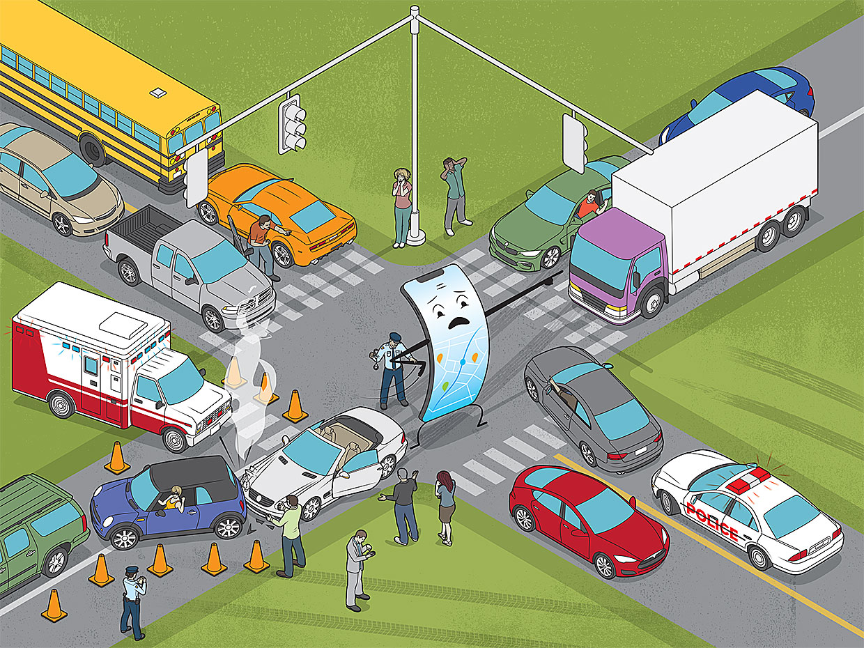
Miguel Street is a winding narrow road that runs through the Glen Park area of San Francisco. A few years ago, only residents of neighboring houses traveled on it, and they well knew all her problems. Now it is packed with cars that use it as a short cut from crowded Mission Street to the popular Market Street. Local residents can hardly get home, and accidents happen daily.
This problem began when the Waze, Apple Maps, and Google Maps apps became widespread, and began to offer real-time traffic jams for drivers. Around the world, about a billion drivers use such applications.
Today, traffic jams appear unexpectedly, in places previously calm, in all cities and countries of the world. In Boston, in the Dorchester area, Adams Street residents complain of fast-moving rush hour cars, many of which drivers stare down at their phones, planning their next maneuver. London bypass routes, formerly the secret possession of taxi drivers, are now filled with application users. Israel was one of the first to suffer from this scourge, since it was there that Waze was founded; such chaos quickly developed that one of the inhabitants of Herzliya-bet even condemned the company.
And the problem is only getting worse. City planners around the world have predicted traffic density based on population density, suggesting that a number of real-time changes will be appropriate in certain circumstances. To handle these changes, they created tools such as traffic lights on highways and highways, variable-sign signs, radio broadcasts, and messaging systems. In especially difficult cases - an obstacle, an unexpected event, an accident - city managers sometimes send a living person to control traffic.
But now real-time navigation apps are responsible for everything, and they create more problems than they solve. Applications are usually optimized so that the travel time of an individual driver is as short as possible; they don’t care whether the streets of residential areas can absorb such traffic, or whether cars appearing in sudden places will increase the danger on the road. I work at the University of California at Berkeley as director of the Smart Cities Research Center. Quite a large part of my work consists of trying to understand what these applications do and how best to coordinate their work with more traditional traffic control systems.
Here's how these apps evolved. Typically, the basic roadmaps used by applications contain five classes of roads, from multi-lane highways to small streets in residential areas. Each class is able to accommodate a certain number of cars driving through them in one hour at a speed adjusted to local conditions. Navigation systems that first appeared as separate gadgets or were built into the control panel, and now are in every smartphone, have long used this information in their path-building algorithms to calculate the probable travel time and choose the best route.
At first, navigation applications used these maps to find all possible paths to their destination. This worked well when users searched for a route while sitting in a car near their home, preparing for the trip. But such searches were too demanding on computing power to be used by drivers who are already on the move. Therefore, programmers came up with algorithms that select several possible paths, estimate the travel time for each of them, and then choose the best. This approach might have missed the fastest route, but on average it worked pretty well. Users could fine-tune these algorithms by choosing their preferred types of roads - for example, preferring highway trips, or vice versa, trying to avoid them.
The digital mapping industry is small. Navteq (now Here Technologies) and TomTom , two early manufacturers of digital cards, were founded about 30 years ago. They mainly focused on data collection, and released map updates on a quarterly basis. Between the releases of the map, the routes offered by the navigators did not change.
When e-navigation capabilities moved to mobile applications, system providers began to collect data on the driving speed and location of all users who allowed the application to share this information. Initially, providers used GPS tracking as historical data that made it possible to evaluate realistic road speeds at different times of the day. They integrated these estimates with maps, defining red, yellow, and green paths - where red means high traffic jams and green means continuous driving.
With the increasing number of historical GPS records, as well as the bandwidth and coverage of cellular networks, developers began to share traffic information with users in almost real time. The ratings were fairly accurate for the more popular applications that were installed by most drivers in a particular region.
And then, around 2013, Here Technologies, TomTom, Waze, and Google went beyond just reporting traffic jams. They began to offer real-time detour options, putting road conditions at the moment above the characteristics of the road network. This gave users the opportunity to circumvent traffic slowdowns, and also created chaos.
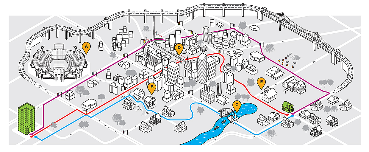
What mobile navigators don’t know : A sports match at local stadium A leads to traffic jams on the highway passing the center of this fictional residential area. For our hypothetical driver trying to get home from work, this is a problem, so he turns to the navigator for help. The shortest - and, according to the navigator, the fastest - alternative path (blue), meandering, passes through residential areas with dead ends, steep climb B and drawbridge C, which can lead to unexpected delays if you are not familiar with its wiring schedule. The red route breaks through downtown D and passes in front of elementary school E; the navigator does not know that the schoolchildren have just unlearned and are going home. Fortunately, our driver knows this area, and he chooses the purple path, although the application says that this is not the fastest option. Drivers unfamiliar with the area in search of a speedy route to the stadium may find themselves in chaotic and even dangerous situations.
At first glance, building detours in real time is not a problem. Cities are constantly doing this, changing signals, phases and duration of traffic lights or displaying detours on the board. The real problem is that mobile navigators do not work in conjunction with urban infrastructures so that most of the traffic moves most efficiently.
First, applications do not take into account the characteristics of each district. Remember those five classes of roads, and the approximate unhindered speeds associated with them? And that’s almost all the apps know about the roads. For example, Baxter Street in Los Angeles - also suffering from an increase in the number of accidents resulting from mobile apps and the detours they prompted - is an extremely steep road along the path that goats used to walk in the hills. But for applications, this road looks like any other road with a low maximum speed. They suggest that on both sides of it there is a place for parking, and between them there is a place for two-way traffic. They do not take into account that its slope is 32%, and that, being at the top, you do not see the road ahead of you or cars traveling towards you. This dead zone forces drivers to slow down unexpectedly, which is why traffic accidents are now constantly happening on a once-quiet residential street.
Also, the algorithms may not take into account other characteristics of their chosen path. For example, are there roads with many pedestrians? Do they pass schools? Are there any intersections that are difficult to drive — for example, a small street crossing a busy street without traffic lights?
I recently experienced what such ignorance can lead to. I was in a traffic jam on a multi-lane road when the application suggested that I go around traffic on roads in residential areas. It built me a route that went right past the school at 8:15 in the morning. There were traffic controllers letting children in, minibuses parked in two rows, there the children jumped out of the stopped cars, and it was difficult for the drivers to see what was happening due to the bright morning sun. And I just brought my share in the general chaos.
Among other things, these mobile navigators work on their own. They come from a selfish point of view, according to which each car competes for the fastest route to its destination. This can lead to the fact that the navigator will generate new traffic jams in unexpected places.
Consider cars crossing a busy street without traffic lights. Suppose for cars on a secondary road put a stop sign. It is also likely that such signs are on a secondary road on both sides of a busy intersection, and this was done when traffic on a busy street was not so dense and the cars did not have to wait too long to cross it. But add cars to the traffic along the main street, and there will be fewer and fewer breaks, due to which the line of cars waiting on the secondary road will begin to stretch and fill the neighboring streets. If you drive along the main road, you will quickly reach your destination. But if you are on a minor, you will have to wait a very long time for the opportunity to drive. And the more cars will send applications to these surrounding streets, as it happens due to unexpected problems on the highway, the more traffic jams and accidents will occur.
Complicating the problem of “selfish routes” is the fact that each navigation provider - Google, Apple, Waze - works separately. Each of them receives data that goes to their servers only from their users, so the degree of distribution of this system affects its perception of reality. If the application is not very popular, the system rolls back to using historical data for the desired area, instead of getting the correct idea of the existing congestion. As a result, several players independently work with imperfect information, expecting that the road network will readily swallow all their users.
Meanwhile, urban transport engineers are busy managing traffic using the tools at their disposal — traffic meters, electronic displays, and radio transmissions that offer detour routes I've already mentioned. Their goal is to control traffic jams, maintain the road network in a safe and efficient condition, and respond appropriately to accidents, sports matches and emergency evacuations.
City engineers also work in isolation and with incomplete information, because they have no idea what the applications will do at any given time. Today's city is losing sight of the amount of traffic that requires access to roads. In the short term, this leads to security problems, and in the long term, a planning problem. This situation does not provide the city with information that it could use to develop improved strategies to reduce traffic - for example, encouraging commercial enterprises to change the schedule of work shifts, and enterprises involved in delivery and transportation - to use other routes.
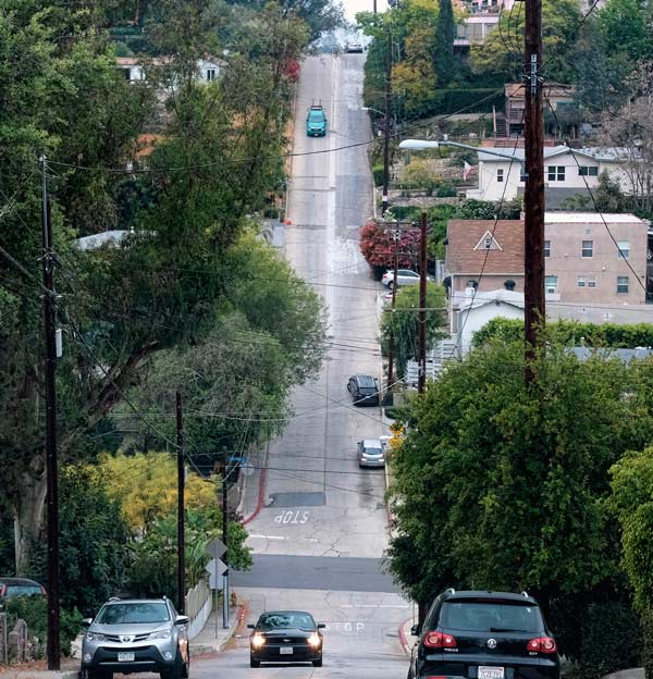
Only for goats? The steep and narrow Baxter Street in Los Angeles was once a network of goat trails, and now for mobile navigators it looks just like any other street in a residential area
You may have benefited from one of these detour routes, but it is unlikely that you will benefit from them in the long run. To do this, it is necessary to treat the system as a whole, and perhaps even consider the total fuel consumption and pollution emissions. Only then can we use these traffic redirection algorithms for the benefit of all citizens and our environment.
Meanwhile, residential areas and their residents are fighting aliens using their streets as highways. At the very beginning of the problem, in the region of 2014, residents tried to deceive the applications and falsified accident reports, trying to make them believe that there were problems that impeded movement. Then some residents convinced the authorities of the need to install lying police officers, slowing down the traffic and reducing the basic speed of driving along these streets.
The city of Leon in New Jersey simply closed many streets for through traffic during peak loads, and began to take serious fines from drivers who do not live there. Neighboring cities followed his example. An unforeseen problem with this solution was that local entrepreneurs began to lose a clientele that could not drive through the city at such hours.
Los Angeles recently reacted to problems with Baxter Street, and made it one-way, with only downhill traffic. The solution was still not perfect - as a result, local residents had to go a longer way, but the randomness of the movement decreased.
The deplorable situation with forest fires in 2017 clearly showed the lack of coordinated work of mobile navigators and traditional traffic management services in Los Angeles. Mobile applications redirected people to the streets, blocked by authorities, right into the mouth of the fire. This is not the fault of the algorithms - it is simply very difficult to maintain up-to-date information on the state of the roads when events develop so quickly. However, this shows that the city authorities need a way to collaborate, and sometimes even influence the operation of these applications. Fortunately, a police officer was in a problem spot, physically redirecting traffic to a safe path.
But all these are temporary measures; they reduce but do not improve mobility. In fact, we need a socially optimal state in which the average trip time is minimized everywhere. Transport engineers call this state equilibrium of the optimum system; this is one of two principles of Wardrop's balance. How do we bring together crowds of people following the directions of the applications and the planned traffic flow, which, at least, is moving towards a socially optimized system, using the mechanisms that we already have? You can start by collecting all points of view on the current state of the road network. However, forcing everyone to dump data into one common boiler will not be easy. This is reminiscent of the story of David and Goliath - players such as Google and Apple have massive server infrastructures that process this data, despite the fact that many cities have only limited financial resources to develop advanced technologies. Unable to invest in new technologies, cities do not catch up with large technology providers, and in the end they are only involved in regulation. For example, Portland, Seattle and many other cities have reduced the maximum speed on residential streets to 30 km / h.
There are better ways. We must convince application manufacturers that if they share information with each other and with city governments, then route-building algorithms will be able to use a much more complete picture, including, among other things, information from the physical infrastructure: traffic light schedules, data from car meters and cameras. Sharing data will improve the quality of their applications while helping traffic management services.
First, we need to form joint committees from representatives of commercial companies, urban engineering groups, and even transport companies such as Uber and Lyft. Sharing information will help us understand how best to reduce congestion and manage our mobility.
There are many problems that must be overcome before all applications and infrastructure tools work together, optimizing traffic equally well for everyone.
The real difficulty with managing traffic seems to be the sheer magnitude of this problem. To use the data stream from application users and data from urban sensors, it will be necessary to create a new analytical layer that accepts key information, anonymizes it, combines and displays it in a form that will be easier to digest for government traffic control systems.
We will also need simulation programs that can use all this data to model the dynamics of our mobility on a city scale. The development of such software is a key topic in ongoing research funded by the US Department of Energy’s Energy Efficient Mobile Systems program, which is run by Here Technologies and three national laboratories: Lawrence Berkeley, Argonne and Pacific Northwest.I am working on this program at Berkeley as a visiting scholar at the Environmentally Sustainable Transport Initiative. Today, a team under my leadership, including researchers from three of these laboratories, has developed simulations for several large cities that can work in a few minutes on supercomputers of the Ministry of Energy. In the past, such simulations worked for days or even weeks. I believe that these simulations will give rise to new congestion management approaches that take into account the many facets of these problems.
In one of our projects, we took 22 million pairs of “start point / end point” (haulage according to the terminology of transporters), and created a simulation for the San Francisco Bay region, which determines the shortest travel time for each haul, as well as traffic patterns on each of the paths all day. We have added an algorithm that redirects cars at a time when the simulation involves the rapid formation of serious congestion. We found that about 40,000 cars are redirected during rush hours, and about 120,000 at rush hours in the evening. Naturally, some kind of accident on the highway will increase these numbers.
This simulation demonstrates how much traffic planning can affect the change in the balance of traffic flow, and also that planning gives us data that we cannot yet receive directly. The next question is which part of the road network we can use, changing highway congestion to increase traffic on roads in residential areas.
Our next step will be to change the algorithm in order to take into account road restrictions in residential areas. We, for example, know that it is not necessary to redirect traffic to places where there are schools at a time when schoolchildren are brought there or taken away, and that we must accordingly correct the algorithms.
We hope that soon we will be able to put these tools in the hands of state traffic control services.
Here is what we are trying to do with this technology to solve the problems described. However, there are not technical obstacles. For example, vehicle location data may contain personal information that cannot be transmitted anonymously. And the current business models of commercial companies may make them reluctant to share valuable data.
To solve technical and other problems, research and alliances between commercial and non-profit organizations will be required, and only then can we create this cooperative ecosystem. But the more we learn about what drives the dynamics of our roads, the more effective our traffic management tools will be, the better they will be able to take into account the problems of local residents, the business goals of car fleet owners, the health and convenience of people.
I am sure that most well-informed people will agree to minor inconveniences for the common good. Would you not agree to spend a few extra minutes driving to spare residential areas and improve the environment?
All Articles