Geoinformational identification of wine. PGI and ZNMP
Hello. I am pleased to continue with a series of articles on an electronic map dedicated to Russian winemaking.
The first article was published a few weeks ago, in it I talked about how I create a map of the vineyards from which wine is produced in Russia ( link to the article ). I got an excellent response, several interesting additions, a positive perception, which gave me inspiration for the second part.
The links provided in the text will be listed at the end of the post for convenience. You can’t skip reading.
Today I would like to discuss the approved, fixed by law, identification of wine by origin, as well as its cartographic presentation. We are talking about the labeling of PGI and ZNMP , which can already be seen on individual units of wine production.
I also included this information, as especially significant in the aspect of the spread of winemaking in Russia, in my map ( link to the map ).
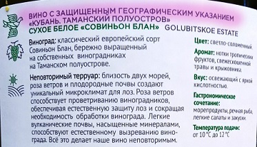
PGI - Protected geographical indication (hereinafter referred to as PGI everywhere). An example of a counter label below (fragment with an inscription):
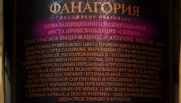
ZNMP - Protected designation of place of origin (hereinafter referred to as ZNMP). An example of a counter-label below (fragment with an inscription):
I hope it turned out readable, gold on dark brown in the hands looks more convincing than in the photo
These concepts were introduced into the Federal Law of November 22, 1995 N 171- “On State Regulation of the Production and Turnover of Ethyl Alcohol, Alcohol and Alcohol-Containing Products and on the Limitation of the Consumption (Drinking) of Alcoholic Products” by another Federal Law of December 31, 2014 N 490 -FZ "On amendments to the Federal Law ....".
As in many other industries, there is one main law in the circulation of alcohol, which is amended by other laws (and not only supplement, but also repeal, edit and interpret). In summary, from the mid-201s, a link to the geographical location appeared in Russian winemaking.
It is only necessary to make a small addition: according to the civil code, article 1516, there is an appellation of origin of goods (NIPT), moreover, with the exclusive right under Article 1229. On wine labels, this labeling is almost never used.
The amended Federal Law, as amended, did not define PGI as an independent term. The law refers to wine products from the PGI , Article 2, paragraph 24 (i.e., about wines, and cognacs, and champagne, no matter how absurd it may sound).
I will not give the definition in full, it is rather cumbersome, I will simply cut it to important points. Wines from PGI are produced from grapes harvested 85% within the geographical area, another 15% must be from the same subject of the Federation.
Theoretically, the status of PGI can be assigned to any geographical object, but in practice, the introduction of PGI is usually the assignment of the status of a wine-making region to the administrative subject of the Russian Federation as a whole.
In addition, a practice similar to the AOC of France was revealed, where larger AOCs contain smaller ones (Bordeaux contains Medoc, which contains St. Julien, which contains various small Crews). As the saying goes, this can only be remembered.
In our case, now PGI Kuban contains PGI Kuban.Novorossiysk. I will not dwell on a detailed listing of all accepted PGI, as well as documents published on this issue. I wrote a post “ Where are the Wine PGIs ”, there I quite fully stated everything that I could find on this issue.
In this article, I would like to refer to the technical part of the mapping of existing PGIs.
As I already noted, the allocation of PGI is administrative in nature, going from top to bottom. The region decides that it is winemaking, and in some cases, also supplements that some areas are the most winemaking (this is in my free interpretation).
In this regard, I am very lucky that there is freeware map data. At the link below, I found several levels of administrative division of the Russian Federation, and in different formats.
mydata.biz/en/catalog/databases/borders_ru
The shape format in this database is with some defects, but geojson, perceived by QGIS , is quite working, also with filled in attribute information.
For my purposes, I needed two levels of administrative division from the base:
If you carefully consider the proposed coverage, it can be noted that territorial waters also include territorial sea waters. This is essentially correct, but not suitable for PGI boundaries.
The sixth level offers a more fractional regional division, which can be used for the correction and layer of regions.
We single out the regions where PGI is adopted. We subtract the polygons of the districts, getting the polygons of territorial waters. Subsequent operation subtract territorial waters from the polygons of the regions. From those regions where a more fractional classification is applied, we subtract regions with independent PGI. The resulting voids are filled with polygons from the district layer.
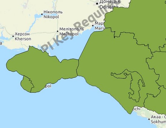
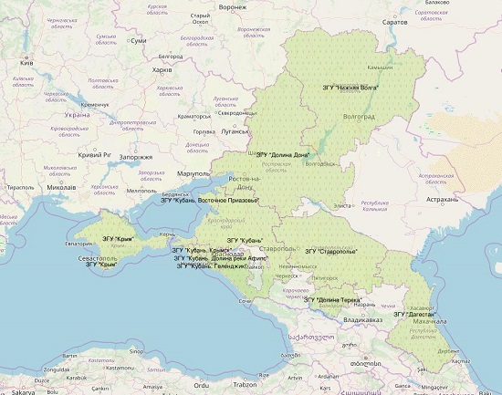
The result of such copy / paste / subtract spatial operations was the layer of the existing PGI at the moment ( link to the map September 2019 ):
At the beginning of the post I gave an example of a label with the PGI “Kuban. Taman Peninsula. ” This is one example of a second-order PGI that is part of the Kuban first-order PGI. There is this PGI since March 6, 2017.
ZNMP is also not defined as an independent term. Article 2, paragraph 25, defines wine products with such a characteristic, but unlike PGI, here the list of criteria is more complete:
In common human language, ZNMP are not only borders, but also people and technologies (in the future, anyway).
I also described the full list of ZNMP in a separate post earlier ( Where are the wine ZNMP )
If we talk, based on existing ZNMP, then we can distinguish a process directed from bottom to top in the administrative chain. The winemaker (or several) initiates the allocation of such a site.
The administrative body, having considered the application, makes a decision in the form of an order. From the point of view of cartography, its text is not essential, but the schemes are quite interesting. It usually looks like this:
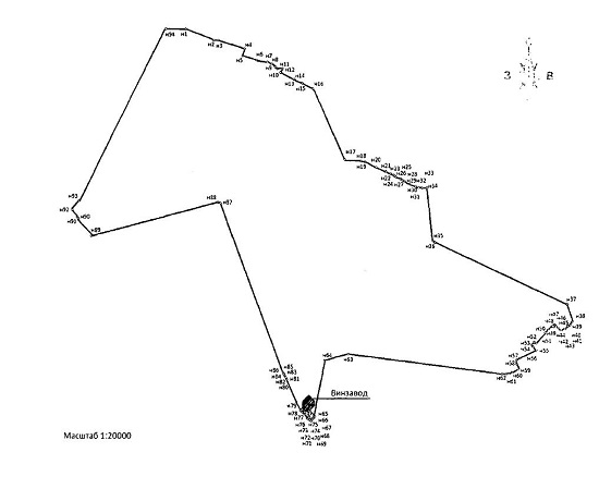
Such a visual diagram is most often accompanied by a list of turning points that are displayed on it. Here it is (fragment):
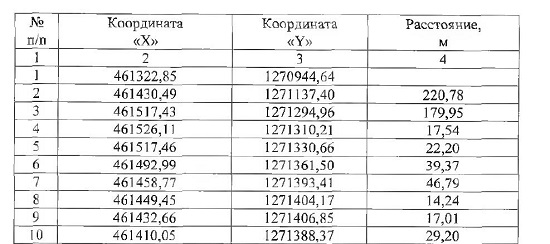
The entire orders are nowhere brought together even within the same region, not like the Federation as a whole. Schemes will give an ordinary citizen a vague memory of the cadastre and possibly the “Book of the Great Drawing”. The catalog of coordinates for most citizens will not give anything.
Therefore, I undertook to put this data on an electronic card. The schemes came in handy to me in order not to confuse X and Y (and I do it all the time), but thanks for the catalogs to the Ministry of Agriculture of the Krasnodar Territory. Because they were laid out in a recognized form, but it was not difficult for me in test editors to bring them to mind:
1272290.86,460617.37
1272296.83,460614.47
1272296.69,460601.51
1272295.84,460584.99
Having prepared text files in this way for each order of ZNMP, I used the standard “line” function (segment) in Autocad, inserting blocks of text into the command line:
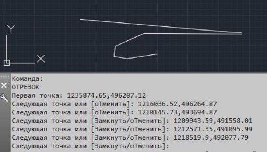
At the output, I received a * .dwg file with polylines in the coordinate system MSK-23.
The fact is that, at the moment, only Krasnodar Territory has managed to select such sections by coordinates. The Rostov region for its only ZNMP (Arpachin) took simply the existing borders of the region.
The coordinate system MSK-23, the local system of the Krasnodar Territory used in construction, cadastre, design (for example, in the Leningrad Region it is MSK-47).
My card was designed with respect to WGS-84 (EPSG: 3395), so the question arose of switching from the MSC-23 to WGS84.
The general averaged parameters of the transition from MSC-23 to SK-42 are openly published on the network. For example, here mapbasic.ru/msk23 :
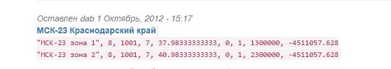
They are very general (in fact, simply transferring the reference zero), therefore, they are not suitable for precise geodetic work. But in my case, the mapping of allotments and gardens of 3-5 meters residuals are insignificant.
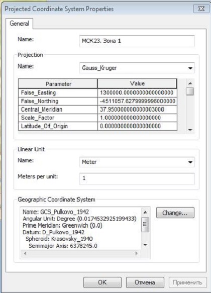
These parameters in the form of a coordinate system based on SK-42 are registered to the received file from AutoCAD. For ArcGIS, they will look like this:
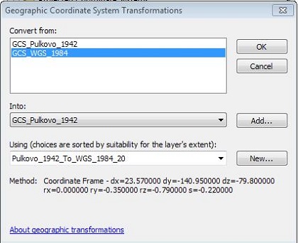
From SK-42 it is necessary to go to WGS-84. In ArcGIS, by default there is a similar transformation, prescribed on the basis of GOST 32453-2017:
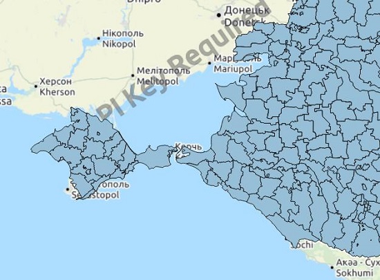
Applying sequentially the determination of the coordinate system and the transformation, it is possible to translate the resulting lines into the desired WGS-84, it remains only to convert the lines to polygons and the LNMP layer is ready ( map link ):
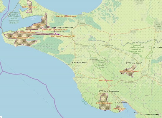
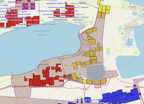
At the beginning of the article, I cited a fragment of the counter-label from products manufactured with the marking of the Sennoye Scientific and Production Enterprise. With a significant degree of certainty, we can say that the contents are made from grapes harvested from one of the yellow polygons in the diagram below:
When I first became interested in the issue, it seemed to me that either the RAR Federal Service or the Ministry of Agriculture provides a list of those areas that are classified in this way. But no. I could not find any officially collected information. So far, everything is contained in disparate acts, orders and decrees.
I'm not alone. Here, too, enthusiasts monitor the status of these entities. Site " our wine ". Moreover, I often look at them for changes.
What's next? I look forward to the introduction of the Kacha River Valley ZNMP. Igor Samsonov (VK “Satera” - Esso, Unplugged, Kacha Valley) talked about the implementation period - November 2019. Perhaps, other PGIs and ZNMP are being prepared. Yandex to help me.
What gives it to the consumer. Only an understanding that products with similar markings are produced within the specified area. But this is already a lot.
If the topic seems interesting, then in the next article I would consider the errors and inaccuracies discovered during the mapping process. Abuse of the labeling of PGI and ZNMP (or rather, misrepresentation). Cases when it is not there, and the grapes are exactly from there. Well, all sorts of "geographical names", "confirmed place of production", "grapes grown in XXX".
References:
The first article was published a few weeks ago, in it I talked about how I create a map of the vineyards from which wine is produced in Russia ( link to the article ). I got an excellent response, several interesting additions, a positive perception, which gave me inspiration for the second part.
The links provided in the text will be listed at the end of the post for convenience. You can’t skip reading.
Today I would like to discuss the approved, fixed by law, identification of wine by origin, as well as its cartographic presentation. We are talking about the labeling of PGI and ZNMP , which can already be seen on individual units of wine production.
I also included this information, as especially significant in the aspect of the spread of winemaking in Russia, in my map ( link to the map ).
Legal basis
PGI - Protected geographical indication (hereinafter referred to as PGI everywhere). An example of a counter label below (fragment with an inscription):
ZNMP - Protected designation of place of origin (hereinafter referred to as ZNMP). An example of a counter-label below (fragment with an inscription):
I hope it turned out readable, gold on dark brown in the hands looks more convincing than in the photo
These concepts were introduced into the Federal Law of November 22, 1995 N 171- “On State Regulation of the Production and Turnover of Ethyl Alcohol, Alcohol and Alcohol-Containing Products and on the Limitation of the Consumption (Drinking) of Alcoholic Products” by another Federal Law of December 31, 2014 N 490 -FZ "On amendments to the Federal Law ....".
As in many other industries, there is one main law in the circulation of alcohol, which is amended by other laws (and not only supplement, but also repeal, edit and interpret). In summary, from the mid-201s, a link to the geographical location appeared in Russian winemaking.
It is only necessary to make a small addition: according to the civil code, article 1516, there is an appellation of origin of goods (NIPT), moreover, with the exclusive right under Article 1229. On wine labels, this labeling is almost never used.
PGI
The amended Federal Law, as amended, did not define PGI as an independent term. The law refers to wine products from the PGI , Article 2, paragraph 24 (i.e., about wines, and cognacs, and champagne, no matter how absurd it may sound).
I will not give the definition in full, it is rather cumbersome, I will simply cut it to important points. Wines from PGI are produced from grapes harvested 85% within the geographical area, another 15% must be from the same subject of the Federation.
Theoretically, the status of PGI can be assigned to any geographical object, but in practice, the introduction of PGI is usually the assignment of the status of a wine-making region to the administrative subject of the Russian Federation as a whole.
In addition, a practice similar to the AOC of France was revealed, where larger AOCs contain smaller ones (Bordeaux contains Medoc, which contains St. Julien, which contains various small Crews). As the saying goes, this can only be remembered.
In our case, now PGI Kuban contains PGI Kuban.Novorossiysk. I will not dwell on a detailed listing of all accepted PGI, as well as documents published on this issue. I wrote a post “ Where are the Wine PGIs ”, there I quite fully stated everything that I could find on this issue.
In this article, I would like to refer to the technical part of the mapping of existing PGIs.
As I already noted, the allocation of PGI is administrative in nature, going from top to bottom. The region decides that it is winemaking, and in some cases, also supplements that some areas are the most winemaking (this is in my free interpretation).
In this regard, I am very lucky that there is freeware map data. At the link below, I found several levels of administrative division of the Russian Federation, and in different formats.
mydata.biz/en/catalog/databases/borders_ru
The shape format in this database is with some defects, but geojson, perceived by QGIS , is quite working, also with filled in attribute information.
For my purposes, I needed two levels of administrative division from the base:
- four - regions;
- sixth - areas.
If you carefully consider the proposed coverage, it can be noted that territorial waters also include territorial sea waters. This is essentially correct, but not suitable for PGI boundaries.
The sixth level offers a more fractional regional division, which can be used for the correction and layer of regions.
We single out the regions where PGI is adopted. We subtract the polygons of the districts, getting the polygons of territorial waters. Subsequent operation subtract territorial waters from the polygons of the regions. From those regions where a more fractional classification is applied, we subtract regions with independent PGI. The resulting voids are filled with polygons from the district layer.
The result of such copy / paste / subtract spatial operations was the layer of the existing PGI at the moment ( link to the map September 2019 ):
At the beginning of the post I gave an example of a label with the PGI “Kuban. Taman Peninsula. ” This is one example of a second-order PGI that is part of the Kuban first-order PGI. There is this PGI since March 6, 2017.
ZNMP
ZNMP is also not defined as an independent term. Article 2, paragraph 25, defines wine products with such a characteristic, but unlike PGI, here the list of criteria is more complete:
- full production within a geographical object;
- characteristic properties: environmental conditions, human factor, technological methods and agricultural activities.
In common human language, ZNMP are not only borders, but also people and technologies (in the future, anyway).
I also described the full list of ZNMP in a separate post earlier ( Where are the wine ZNMP )
If we talk, based on existing ZNMP, then we can distinguish a process directed from bottom to top in the administrative chain. The winemaker (or several) initiates the allocation of such a site.
The administrative body, having considered the application, makes a decision in the form of an order. From the point of view of cartography, its text is not essential, but the schemes are quite interesting. It usually looks like this:
Such a visual diagram is most often accompanied by a list of turning points that are displayed on it. Here it is (fragment):
The entire orders are nowhere brought together even within the same region, not like the Federation as a whole. Schemes will give an ordinary citizen a vague memory of the cadastre and possibly the “Book of the Great Drawing”. The catalog of coordinates for most citizens will not give anything.
Therefore, I undertook to put this data on an electronic card. The schemes came in handy to me in order not to confuse X and Y (and I do it all the time), but thanks for the catalogs to the Ministry of Agriculture of the Krasnodar Territory. Because they were laid out in a recognized form, but it was not difficult for me in test editors to bring them to mind:
1272290.86,460617.37
1272296.83,460614.47
1272296.69,460601.51
1272295.84,460584.99
Having prepared text files in this way for each order of ZNMP, I used the standard “line” function (segment) in Autocad, inserting blocks of text into the command line:
At the output, I received a * .dwg file with polylines in the coordinate system MSK-23.
The fact is that, at the moment, only Krasnodar Territory has managed to select such sections by coordinates. The Rostov region for its only ZNMP (Arpachin) took simply the existing borders of the region.
The coordinate system MSK-23, the local system of the Krasnodar Territory used in construction, cadastre, design (for example, in the Leningrad Region it is MSK-47).
My card was designed with respect to WGS-84 (EPSG: 3395), so the question arose of switching from the MSC-23 to WGS84.
The general averaged parameters of the transition from MSC-23 to SK-42 are openly published on the network. For example, here mapbasic.ru/msk23 :
They are very general (in fact, simply transferring the reference zero), therefore, they are not suitable for precise geodetic work. But in my case, the mapping of allotments and gardens of 3-5 meters residuals are insignificant.
These parameters in the form of a coordinate system based on SK-42 are registered to the received file from AutoCAD. For ArcGIS, they will look like this:
From SK-42 it is necessary to go to WGS-84. In ArcGIS, by default there is a similar transformation, prescribed on the basis of GOST 32453-2017:
Applying sequentially the determination of the coordinate system and the transformation, it is possible to translate the resulting lines into the desired WGS-84, it remains only to convert the lines to polygons and the LNMP layer is ready ( map link ):
At the beginning of the article, I cited a fragment of the counter-label from products manufactured with the marking of the Sennoye Scientific and Production Enterprise. With a significant degree of certainty, we can say that the contents are made from grapes harvested from one of the yellow polygons in the diagram below:
Instead of conclusions
When I first became interested in the issue, it seemed to me that either the RAR Federal Service or the Ministry of Agriculture provides a list of those areas that are classified in this way. But no. I could not find any officially collected information. So far, everything is contained in disparate acts, orders and decrees.
I'm not alone. Here, too, enthusiasts monitor the status of these entities. Site " our wine ". Moreover, I often look at them for changes.
What's next? I look forward to the introduction of the Kacha River Valley ZNMP. Igor Samsonov (VK “Satera” - Esso, Unplugged, Kacha Valley) talked about the implementation period - November 2019. Perhaps, other PGIs and ZNMP are being prepared. Yandex to help me.
What gives it to the consumer. Only an understanding that products with similar markings are produced within the specified area. But this is already a lot.
If the topic seems interesting, then in the next article I would consider the errors and inaccuracies discovered during the mapping process. Abuse of the labeling of PGI and ZNMP (or rather, misrepresentation). Cases when it is not there, and the grapes are exactly from there. Well, all sorts of "geographical names", "confirmed place of production", "grapes grown in XXX".
Thanks for your attention!
References:
- Federal Law of November 22, 1995 N 171-
- Federal Law of December 31, 2014 N 490-
- First article: Electronic map of winemaking in Russia. Design and content
- Zen Post: Where are the PGI Wine Rooms
- Zen Post: Where are the Wine ZNMP
- Open data with the borders of administrative entities of the Russian Federation
- QGIS Free GIS Software
- Parameters of local coordinate systems on the Mapbasic resource
- Electronic card printed with PGI and ZNMP
- Our Wine website, a list of PGI and ZNMP
All Articles