Electronic map of winemaking in Russia. Design and content
The reason for my registration and this publication was a read post about a visit to the Koktebel plant, the history of which the author doubted ( link ). Fake wines do not exist on sale.
Personally, I am very interested in Russian winemaking. Having minimal skills in working with online GIS, I try not only to collect information about the situation, but also to map it. I keep a constantly updated winemaking card ( link to the card ).
A considerable amount of wine is produced in Russia. But for me, without localization, it looks faceless. The question is “where”, perhaps even more important than the question “how” and “from what”, and even more so “who”. The statements of many network "bloggers" and the common opinion that we have no fault of our own served as a definite trigger for my project. In the USSR it was, and now not. I try to refute it with my card. I do this as reasonably as possible, my data can and should be checked (sometimes I am mistaken, and then I correct).
Content and Content
There are probably many ways to map wine. For example, French and Italian wine cards display terroirs, appellations, varieties tied to them. We have neither one nor the other, nor the third. Australians show the volume of exports sorted by species varieties, as well as its direction.
At the very beginning, I started with vineyards. The logic was very simple. The vineyard is visible in satellite images, moreover, the vineyards are very often noted in wikimapia, have their own category ID (4582). Accordingly, there is a producer - there is a vineyard. We find a winery, find landings - we gradually create a map. Everything is simple.
It is necessary to make a reservation that, unlike beer (which does not matter where to brew), wine is made from grape must (it is must, it is juice, depending on the industry), transportation of ripe grapes is a necessary but minimized measure, so how the raw material is deformed. Therefore, wineries are most often located as close as possible to the source of raw materials, and they transport the finished wine material (i.e. wine in industrial containers).
The technical side of the issue
The collection and analysis of information I will describe below. The technical basis of my cartographic experiments comes down to the fact that the source data (mainly pictures, lines from Wikimapia, diagrams) are uploaded to ArcGIS, where I create thematic shape-files and maintain the main database (antiquity, of course, but I'm so used to it).
The initial data, like satellite images, are generated in the SAS Planet environment ( project site ). I usually use a level of detail of level 18, which is enough to determine the rows of planted vines. I try not to get attached to one source, choosing the most informative.
As a mathematical basis, I chose EPSG: 3395, that is, the standard WGS84 Mercator. It is picked up on the fly by any cartographic support, which makes it especially possible not to recall the projection.
For maximum information, I set several fields of the current database of vineyards:
- Winery The name of the winery itself. It often does not coincide with a legal entity.
- Grape Grape sort. At first it seemed to me that it would be simple - to differentiate plots by grades. Now I am leading the field, rather, for the query - who makes a malback? The same “Fanagoria” operates with more than one hundred varieties - it is technically impossible to introduce them into fields. But the field remains.
- Found_date. If possible, I enter the date of the establishment of the vineyard. This allows you to evaluate how young vines are used by the manufacturer for winemaking.
- AOC_date. This field is the date of issue of the PGI license ( ZNMP ), I also decided to add the license numbers of farms there. It is important to understand that some manufacturers cannot produce PGI products. (An example of the Bournier winery, now the market is 2011-2015, and they were licensed in 2017, respectively, we will see their PGI products closer to 2021)
- AOC_N. License number in the FS RAR system. You can always go to the website of the federal service and check the relevance of the license by number ( link to the registry site ).
- AOC_name. The name of the PGI within which the winery operates, if it is licensed.
- DOC_name. Name of ZNMP , within which the winery operates, if it has the appropriate license.
- Area. Vineyard area in hectares. To understand the volume of space and the "power" of the winery.
As an online mapping service, I chose NextGIS ( project site ). When the question arose of publishing shape files on the network (so that the map can be shared at any time), the priority for me was free, the presence of a good sub-base, functionality (the simpler the better). Actually NextGIS + their QGIS practically had no analogues.
They are free at my level (I have 3-4 layers of power for a map), the QGIS functionality is quite functional for creating maps, and I keep the main content in ArcGIS + and keep a backup copy.
I broadcast links to the updated map on Twitter ( account on Twitter ), then to embed in the blog and telegrams.
The working process
Oddly enough, the workflow begins with the card in the store. Just yesterday I was at Magnit, which is next to the Triumph Palace in Moscow, where I bought this for 219 rubles:
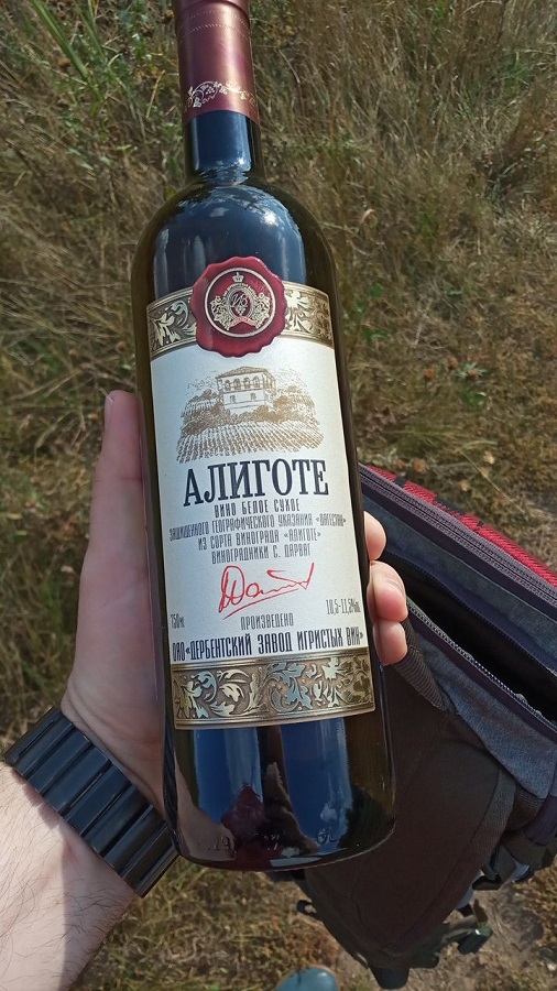
What is important, except for monograms and other ruffles. Firstly, a reference to the PGI (There are some legal issues with the PGU Dagestan, but not about them yet), i.e. there are indeed landings, and secondly, a direct reference to the location is the village of Darvag.
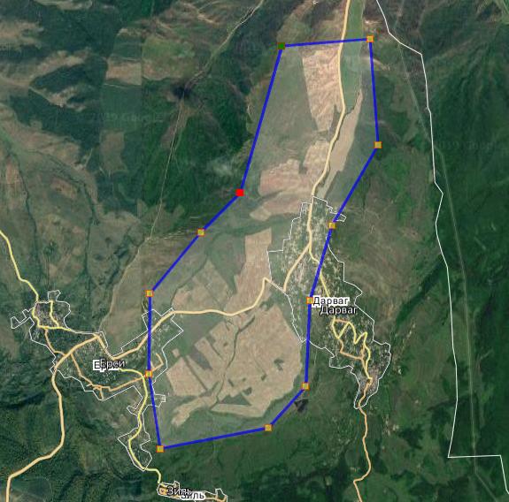
First we look at Wikimapia, what we have in Darvag. In general, there is nothing especially. Information about the village is stingy: The population of the village is 2527 people (2008), 2825 (2017), Azerbaijanis. Separate village council of Tabasaran district. Other objects around the village were not allocated. The only, we note, 42 parallel - for Russia, it turns out, the most southern vineyards known to me. This brown section with clear borders is very similar to the agricultural one.

Go to Google Earth. The fact is that in Wikimapia, the pictures are not very well selected for the season. Whether it is early spring, or autumn. Different inclusions indicate that different varieties either turn green at different times, or only partially collected. There is a chance that some of the crops are simply abandoned (this is found in the Crimea, and in the Kuban too, but less often).
Moving the time lapse, it is possible to determine what the best outlines are in the April 2017 picture. The rows look fresh, well-groomed, without weeds and sprouted trees (a sign of degradation). We can conclude that these are actually operated landings:

Spotted heterogeneity is most likely expressed due to the microrelief and the difference in moisture. We check how much this area spreads, and then open it in SAS Planet.
In principle, it would probably be possible to use one product, but why do you have to use three. Wikimapia gives a good address binding, the database is large, you can search for any key information up to the name of the winery. Google Maps is needed to scroll through the timeline (time-lapse), the pictures are of different times, the seasons change, something is uprooted, something is laid down, sometimes it all looks ambiguous. SAS Planet allows you to unload all this in the projection, which we do:
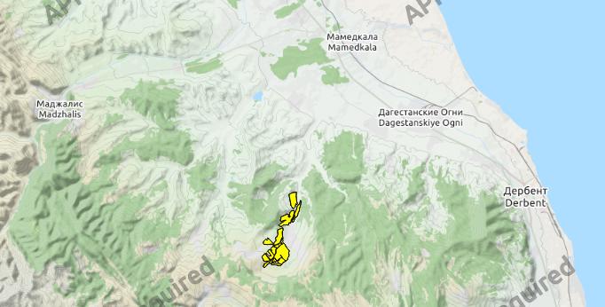
Now we have a transformed * .tif with coordinate snapping, which can be loaded into ArcGIS. Digitization is the least interesting stage in my story, while the most delicate place of the project - for example, to apply the Massandra vineyards, I still lack spirit. But my personal victory is the digitization of plantations of the agricultural company "South" (daughter-operator "Kuban-Vino").
To apply vineyards is a technical task. In total, it turned out that the total area of fields under the village of Darvag is about 850 hectares. But some questions remain:
- Do they all belong to the Derbent sparkling wine factory? For now, we can only make the assumption that yes. Although we remember that there is still a cognac Derbent factory, and there is Kizlyarsky. They also work with something.
- Are they all planted with industrial grapes? Most likely, yes. But it is possible that part of the plantings is table grapes.
- Are they all used? Most probably not. Some of the vineyards in the western part have very ragged edges, as well as trees. But at this stage it is better to leave it that way.

To estimate the volumes: 850 hectares - this is comparable to the "Fanagoria", huge areas, summarizing.
Sometimes representatives of wineries come to me (or I write myself) through social networks, which allows me to clarify the information. So it was with “Fanagoria”, “Perovskikh Manor”, and the Massaraks micro-winery themselves was asked to show them on a map. Perhaps, in this case, there will be someone who either confirms the information from the card or refutes it.
Now you need a little surfing to replenish the database.
We know the name of the winery on the label: OJSC "Derbent Sparkling Wine Plant". We fill in two corresponding fields, this time they coincide (Winery and Legal Entity).
Now you need to decide on the grapes. Aligot from the bottle is in the hands, but you need to find out what varieties are still grown. To do this, we turn to the site of the plant ( link to the site ). There is no complete list, it remains to rewrite those varieties that are mentioned on the labels: aligote, cabernet sauvignon, chardonnay, nutmeg, kara-koysu (autochthon, by the way), rosalia.
In addition, we learn from the site that in addition to the above, there are plantings of rakatsiteli, Riesling, Augustin. The lands were leased in 2009, the total area of 1300 hectares (this is comparable to the 850 hectares that came out of me). More information can be found here link to the site .
We will consider the vines planted in 2009, which we add to the base. If possible, we will adjust subsequently.
Probably need a little digression. Judging by the site, the plant in Derbent belongs to the new Russian winemaking. By and large, its history begins in 2006, when a new Italian equipment line was delivered to the plant. In 2009, the areas where vineyards are now located were rented. It was then that their director Magomed Sadulayev ( here is the profile on the names of the Caucasus ) attracted investments for the "revival" of winemaking in Dagestan. And almost all of the winemaking in Russia is “reviving”.
From the site we find out the TIN of the plant: 0542001269 and go to the site of the FSRAR ( link ). There are no questions to the plant. There are two licenses for the production of products with a protected geographical indication. I take one that refers to still wines. No. 05PVN0006336 dated January 19, 2017.
We supplement the base with this information - PGI "Dagestan". Technically, the filling of the card is completed. Go to NextGIS.
In NextGIS, I have * .geojson format coverage containing all previously digitized vineyards. I used to maintain the database in a shape-file, but along the way it turned out that there were significant shortcomings - errors appeared during editing (the deleted polygon was restored, for example).
I load the updated file in ArcGIS shape file, paste it into geojson using the copy tool. Everything is ready. Next, the selected layer is imported into the online version.
Unfortunately, NextGIS (at least for the free version) does not imply updating the created layers, each time importing them as new. It turns out that in the final map window duplication of layers is created. Usually I leave the last 3-4 updates, because they are referenced by previous publications, and if they are removed, the user will have to turn on the checkmark in the upper left corner - which is not very convenient.
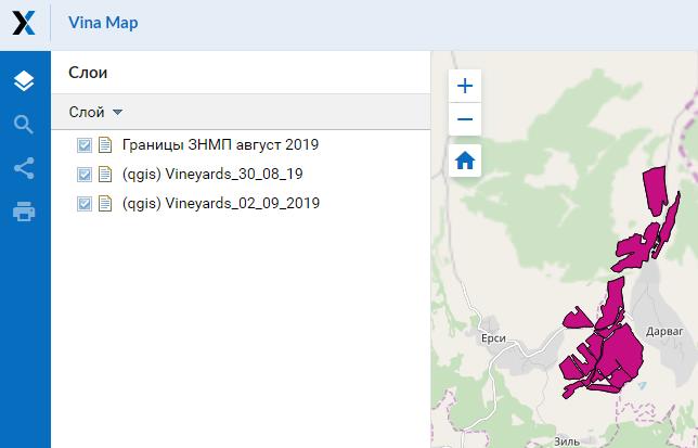
At the end of the next iteration, I post the link to the map on Twitter. Twitter is a rather archaic system, but what's nice about it is that it allows you to create a post containing text + screen + link to the map, and tags (although I'm too lazy to come up with them):
Vineyards of OJSC Derbent Sparkling Wine Plant. Vineyard map update https://t.co/EjsXTa3jVI pic.twitter.com/Z8pueWStqK
- Citron Tsyurupinsky (@ZytZyr) September 2, 2019
Habrahabr - understands them so. Other sites display pretty close to how Twitter does it.
What's next. When I was at the very beginning of the journey, it seemed to me that to solve my own problem it would be enough to find 10-20 wineries, and I will close the question. But no - even this bottle is an opening for me (I thought that such enterprises work exclusively on the Uzbek beam - I was mistaken). Constantly receive news about new projects, new masters, team relocation (from the last: the Alma Valley team switched to the Eya-Yeysk project, and they have already released something). In addition, you have to apply related information. I made a layer of ZNMP , having drawn through the orders of the Ministry of Agriculture of the Krasnodar Territory, and soon I will lay out a layer of PGI , having analyzed the relevant decisions. It would be nice to create a dot layer of the wineries themselves.
That's all for now. So far, I’m quite deliberately not paying attention to the fact that there is a cork from Derbensky sparkling wine factory, but I think this is an interesting enterprise to mention about it. If the topic seems interesting, we will continue with winemaking, GIS, tasting bases, and also consider the concept of PGI and ZNMP .
All Articles