Nature has bad weather, and we at Toshiba have no doubt about it. But mankind has learned to effectively predict inclement weather quite recently, and the path to these achievements lay through personal tragedies, world wars, and “partisan rains”. We give a brief excursion into the history of meteorology, tell how weather radars appeared and why the newest weather supercomputer was named after the most ancient god.
At the dawn of meteorology: why did the first weather forecaster commit suicide?
Recently, paleoclimatologists have come to the conclusion that the ancient Akkadian state (it existed about 4 thousand years ago) fell into decay due to the intensification of seasonal dust storms (the so-called “shamals”) in Mesopotamia that violated agriculture. And even then, humanity was trying to monitor the weather and predict it. But it didn’t work out very well - poor Akkadians.
The breakthrough came only in the 19th century, because the first secret of a successful forecast is observing the weather from different geographical points at the same time. For the first time this became possible with the advent of a new means of communication - the telegraph, which helped build the first meteorological service, which not only observed the weather, but also predicted it (as it could). It's about the Department of Meteorology under the British government. Its creator in 1854 was British Navy officer Robert Fitzroy, captain of the Beagle ship, on which Charles Darwin made the famous voyage around the world. During his long career, Fitzroy has documented a huge amount of weather observations. True, the activities of the new body were limited to creating a wind map for the captains of the fleet, which, of course, could not be called a forecast.
On October 25, 1859, the Royal Charter passenger ship crashed off the coast of England. A sudden powerful storm broke it on the rocks off the west coast of England, killing 456 people. The crash of the Royal Charter in its native waters hit Fitzroy (I wonder how he would react to the history of the Titanic half a century later). The head of the Department of Meteorology ordered the creation of a network of 24 weather stations in major ports in England, Denmark, Holland and France to prevent storms. The recently invented telegraph helped with this Fitzroy, who transmitted weather data to the headquarters by the Morse code.
In addition, Fitzroy ordered the storm classes to be installed on all ships of the Royal Navy - hermetically sealed flasks with a mixture of water, ethanol, potassium nitrate, ammonium chloride and camphor. The liquid in this device reacts to weather changes, for example, cloudiness portends rain, and transparency - clear weather.

Judging by the high crystals that have risen high, this stormglass promises severe frost and cold. However, further technological progress in meteorology threw this device into the dustbin of history, without even leaving scientists time to study the principle of its action. Source: ReneBNRW / Wikimedia Commons
Armed with thermometers, barometers, storm classes, a long-term "big date" of observations, as well as readings from a network of weather stations, Robert Fitzroy began to publish weather forecasts for 1-2 days in advance. The first such forecast appeared in The Times in 1861.
Weather forecast for August 1, 1861. Clear weather was expected in London, a moderate southwest wind and 17 degrees of heat. Whether the forecast came true, we do not know. Source: Official blog of the Met Office News Team
The first weather forecaster quickly made enemies. Scientists criticized his methods. The British press relished the setbacks. The owners of the fishing business were preparing to present an invoice for losses, because fishermen often refused to go to sea, receiving a bad weather forecast from Fitzroy. By 1865, the already elderly rear-admiral weather forecaster was depressed, wasting almost all of his fortune on meteorological research, and on April 30 laid his hands on himself.
Fitzroy’s forecasts could not be accurate: there were few weather stations, data processing was carried out manually, and extrapolation of old weather observations often failed. But the main weak point of his practice was weather measurements based on indirect data (temperature, pressure), while a successful forecast requires direct monitoring of the movement of air masses.
Another century passed before humanity learned this. As is the case with many other technical solutions of the 20th century, the arms race helped progress.
On the weather front: how did the military learn to predict the weather?
In 1904, 22-year-old German engineer Christian Hülsmeier presented a mysterious device in Cologne, which was called the “Telemobiloskop”. Each time, when a ship passed in a certain area of the nearby Rhine, the telemobiloscope made a ring. This device consisted of a spark radio transmitter connected to multiple antennas. A telemobiloscope picks up electromagnetic waves reflected from large metal objects (ships). However, those present at the presentation presented the German Navy then the apparatus was not appreciated.
And very in vain, because already in the 1930s. Scientists from the USA, Great Britain, Germany, France, the USSR, Japan, Italy and the Netherlands almost simultaneously began developing similar devices based on broadcasting radio signals and capturing echoes reflected from various objects. They were called upon to detect the movement of aircraft and ships of a potential enemy at long distances. The principle of operation of these transmitters was also the basis for meteorological radars operating to this day.
The antenna emits microwave waves in the form of short-term high-power pulses. The radiation is focused into a narrow radio beam. When a pulse encounters an obstacle in its path, part of its energy is also dissipated towards the receiver, which usually works next to the transmitter on the same antenna. The radio echo is weaker than the sent pulse and returns with a delay. The difference in the power and speed of these pulses makes it possible to determine the position in space, speed, density and other physical parameters of an obstacle, for example, an airplane or a thundercloud.
By the beginning of World War II, such systems were created, and one of them (American) gave the world a new word "radar" (derived from the abbreviation RADAR, Radio Detection And Ranging).
In 1941, English operators first observed illuminated areas from heavy rainfall on the radar display. Later, the military drew attention to the radio noise that came from clouds, snowfalls and hail. These data began to be used to clarify the weather and coordinate pilots and sailors. And after the war, part of the military radars were transferred to meteorologists to monitor the weather. For example, in the United States, the naval forces rebuilt the AN / APS-2 radar, previously used to search for German submarines, and sent it to the US Weather Bureau in 1946 under the name WSR-1 (Weather Surveillance Radar).
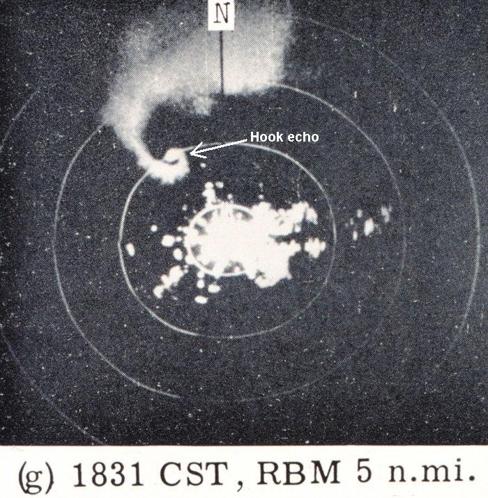
This is what American tornado meteorologists saw using the WSR-3 weather radar, and Hook Echo is the name of a tornado-like cloud formation observed on the radar (hook in English - “loop”). Source: Wikimedia Commons
In the post-war period, the principle of operation of weather radars did not change, but their design became more complicated - to obtain more accurate data on the size and amount of precipitation, their distribution in the atmosphere, speed and direction of movement. However, the climate on the planet is gradually changing, and in some regions a variety of destructive weather events are intensifying, requiring new forecasting methods.
What are "partisan hurricanes" and why ordinary radars can not cope with them?
Many people know about the difficult seismic situation in Japan, but few have heard about the so-called “partisan” hurricanes or storms (guerrilla rainstorm) that are frequent for these places - due to their coastal position, Tokyo often suffers from them. When wet ocean air collides with air masses heated in a densely built-up city, huge cumulus clouds form. The process of their formation is very fast, and even faster it is followed by a powerful downpour, provoking floods and flooding, sometimes with human casualties. That is why such hurricanes were called "partisan" - their blow is always unexpected.
To predict such phenomena, two main types of traditional meteorological radars - multi-parameter and with a phased antenna array - are not suitable.
Multiparameter meteorological radars are double polarized, that is, they can simultaneously transmit and receive horizontally and vertically polarized waves. This allows them to effectively track rainfall down to the size of raindrops. However, such a radar also has drawbacks: its parabolic antenna (in the form of a plate) can transmit and receive electromagnetic waves only in the direction to which it is facing. The signal has the shape of a thin beam, so to calculate the distribution of precipitation, you need, like a spotlight, to turn the antenna up, and then gradually tilt it to the ground. It may take from one to five minutes to observe the distribution of precipitation near ground level, and more than five minutes to measure precipitation in a three-dimensional projection. This is precisely what prevents the “cumulus cloud” in which “partisan rainfall” is hiding quickly.
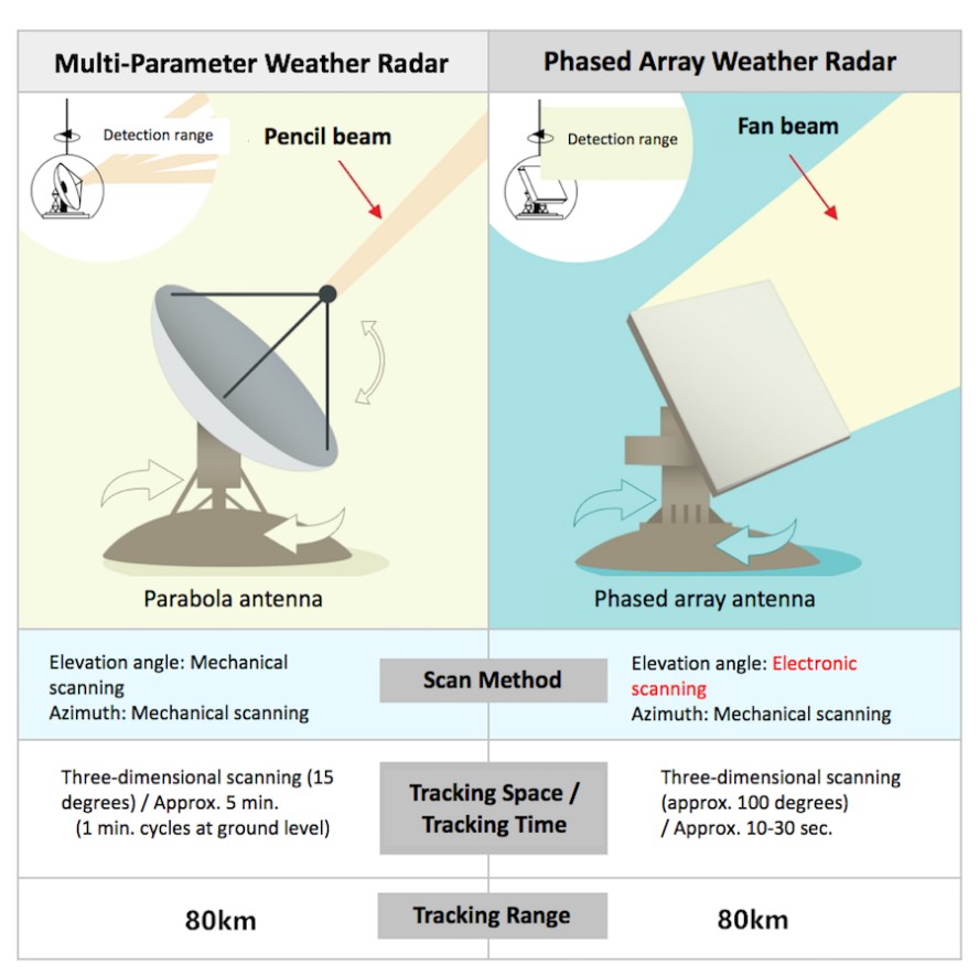
The first type of radar emits a more powerful signal, and the second - a more diffuse one. Source: Toshiba Clip
Unlike multi-parameter radars, phased array weather radars are flat antennas, usually square or polygonal. More precisely, they consist of many small antennas placed on a plane (something similar to the faceted eye of an insect). Its structure allows you to instantly change the direction of the waves without having to move the antenna up or down. This type of radar allows you to radiate and receive waves (from earth to sky level) almost continuously. But its weak point is the calculation of precipitation, because their signal is more diffuse.
If a multi-parameter radar measures the amount of precipitation well, then a phased array radar is better at building a picture of their distribution. But in order to detect the “partisan hurricane”, it was necessary to combine these two radars in one.
Already with a hedgehog: how in Toshiba connected a circle and a square?
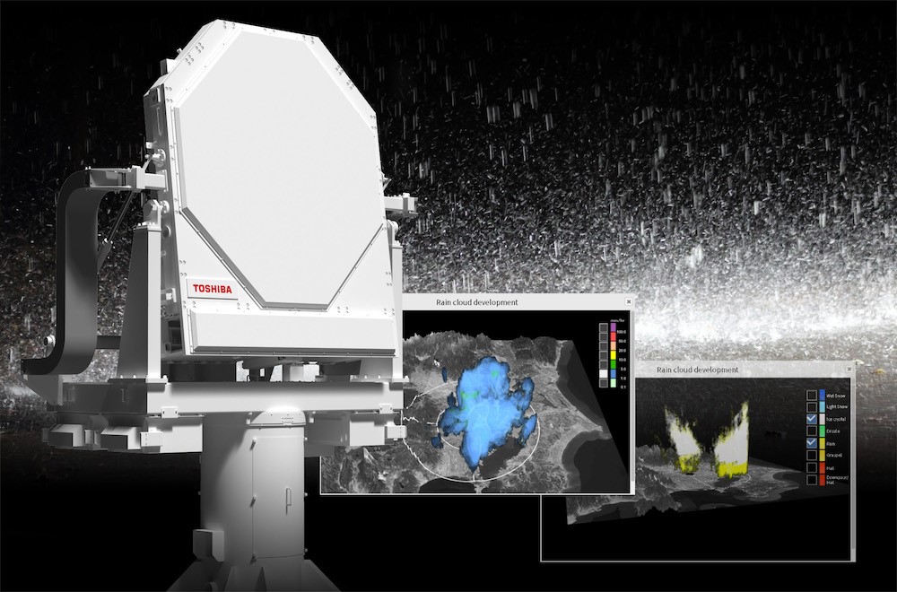
Toshiba engineers as part of the research team of the Council on Science, Technology and Innovation under the Government of Japan created the world's first multi-parameter phased array radar, that is, they combined two traditional types of radars into one device. It has a double polarization and can form a signal beam simultaneously in ten directions. Thanks to this, such a radar is able to find a “partisan cloud” in a radius of 60 km in just 30 seconds (and in a radius of 80 km in a minute).

The first multi-parameter phased array weather radar was located on the roof of Saitama University in December 2017. Source: Toshiba Clip
A maximum coverage range of 80 km allows one radar to control the weather situation over almost the entire metropolitan area of Tokyo. For example, during the 2020 Summer Olympics, radars will be able to warn of “partisan rains” and help city officials coordinate the movement of tourists and citizens in the event of inclement weather.
Subsequently, in Japan, a network of new weather radars can be created that will cover the entire territory of the country. However, the more weather research tools, the more difficult it is to process and interpret the information received. Therefore, in the future, humanity must solve the problem of creating a global weather control system based on supercomputers. It seems that a breakthrough in this area was prepared by our colleagues from IBM.
God of a clear day: how will the new supercomputer predict the weather?
In November 2019, IBM announced the development of the Global High-Resolution Atmospheric Forecasting System (GRAF). It will be based on the DYEUS supercomputer, built specifically to control the virtual global weather model. By the way, the name DYEUS ("Dieus") is not accidental - that was the name of the supreme god of the pre-Indo-European pantheon, who was responsible for a clear sky over the heads of our ancestors 3-5 thousand years ago.
DYEUS uses the Power9 processor, which also runs on Summit, the world's most powerful supercomputer. Source: Weather Co.’s YouTube Channel
Sources of information for the computer will be not only weather radars, probes and satellites, but even sensors on board airliners and smartphones around the world. The latter will be able to transmit data on temperature and pressure (with the permission of the users, of course). GRAF will be able to detail the weather for areas 3-4 km wide instead of 10-12 km, and forecast updates will arrive every hour instead of the usual 6-12 hours. By the way, the application with GRAF forecasts - The Weather Channel - can already be downloaded to your smartphone