We use the program Androzic - offline gps-maps are still relevant
Hello geektimes! The vacation period is coming to an end, however, long trips continue to be relevant. Now it’s “stylishly fashionable for young people” to use various online services, but since then, when gps-receivers were big and yellow, good old offline maps have not lost their relevance - the Internet is either missing, expensive or inconvenient when traveling. Yes, even in the home region the mobile Internet is not always connected, often it is simply not needed to pay for it separately. And there are gps in almost any smartphone, and you don’t have to pay anything for using it.
I will tell you how to prepare offline maps for the undeservedly forgotten Androzic program, which I have been using for more than 5 years, and which I have used on all my trips, from Paris to Solovki.
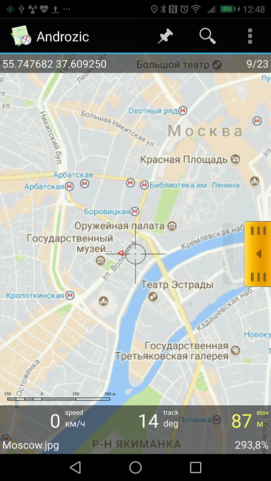
Here is the map on my Android 7.0 smartphone:
How to do this, a little digital archeology under the cut.
First you need to put this program. You can download it from the site of the same name , the program is completely free, and there is a link to the source code on github on the site. Unfortunately, the author has stopped developing the program, but everything works as it is - the program does what it needs and does not do what it does not. I use version 1.7.9, with 2.3 something didn’t grow together, but I was too lazy to understand. So the further story will be about 1.7.9.
So, download from the apk site, install on Android. The program provides everything that is needed for offline navigation - maps, points, distance, speed, etc. (of course, there are no online services such as traffic jams, the program does not).
Included with the program cards, too, no, so they will have to prepare their own. Getting digital archeology - we need programs that were used 10 years ago :)
First we need to create a map in OZI Explorer format. Having tried different programs, I finally settled on SAS.Planet . The program is free, with its help you can save the map in any convenient format. For example, let's create a map of Moscow.
Select the desired area, select the desired zoom (z15) and click Start - the program downloads all tiles from Google maps (I don’t know how much this is allowed by Google’s policy, but I think it’s possible for personal use).

Open the previous selection again, select Stitch and download the map in jpeg format (the same zoom is selected = 15 and the map option is turned on to create an ozi file).
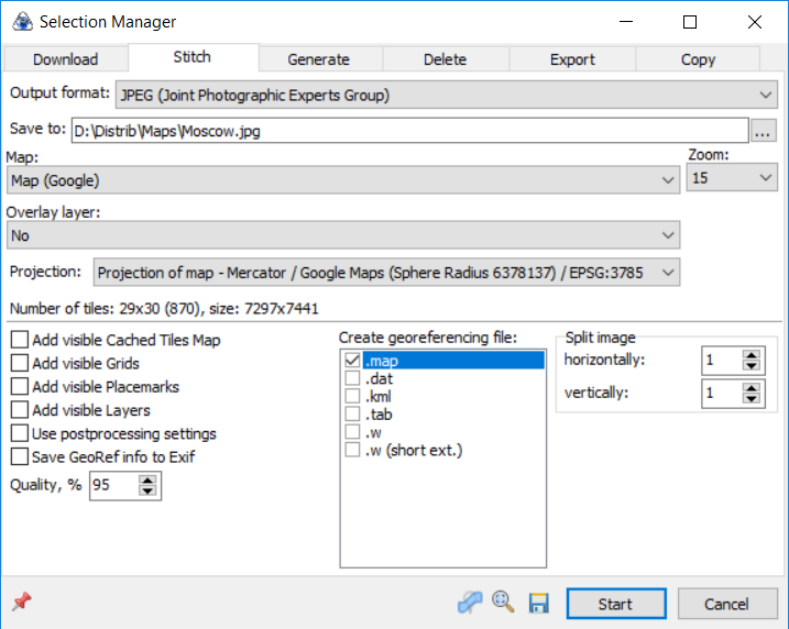
The result - 2 files should appear in the selected folder - Moscow.jpg (approximately 7000x7000 pixels in size) and Moscow.map. Now our task is to convert the card and install it on a smartphone.
The next step is to convert the card into a format that Androzic understands. Unfortunately, the files saved above do not open directly, the map first needs to be converted to ozfx3 format. For conversion, I used Img2OZF 3.0. Later versions are not suitable, because they create files in a different ozf4 format (it was possible to download version 3.0 from here , since the official links have long been dead). If anyone knows another converter, it would be interesting.
Using the program is very simple - select a folder, click Convert.
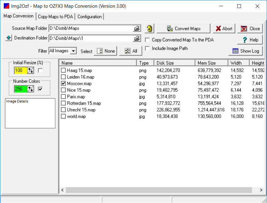
The program creates map layers for different zoom levels, after a while the map is ready. As a result, 2 Moscow.ozfx3 and Moscow_ozf.map files were created in the output folder.
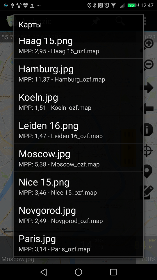
The last and easiest stage. We connect the smartphone via usb, and copy both files into the / Androzic / maps folder. Restart Androzic - everything is ready, the new map is visible in the list, and you can open it.
If you wish, you can also add a list of interesting points in Androzic, and the program will show them on the screen. Hint - if in google maps you select the item “what’s this” in the context menu, the coordinates will be shown in the form of latitude-longitude, and they should be entered into the program.

What did we get in the end? We have a free program showing our location, map, speed, coordinates, a list of interesting points on the smartphone, recording the motion track, everything is completely offline, without any use of traffic or gsm network at all. No ads, registrations and sms. When traveling in roaming / abroad, or even on an airplane, see where we are flying now, what the doctor ordered.
Edit
As suggested in the comments, there are several alternative programs that work completely offline and do not require conversion of maps.
Maps.me
OSM Maps
OruxMaps
Locus
7Ways
Galileo
All successful travel. If the author Androzic also reads this article - Respect for a great product.
I will tell you how to prepare offline maps for the undeservedly forgotten Androzic program, which I have been using for more than 5 years, and which I have used on all my trips, from Paris to Solovki.
Here is the map on my Android 7.0 smartphone:
How to do this, a little digital archeology under the cut.
Androzic program
First you need to put this program. You can download it from the site of the same name , the program is completely free, and there is a link to the source code on github on the site. Unfortunately, the author has stopped developing the program, but everything works as it is - the program does what it needs and does not do what it does not. I use version 1.7.9, with 2.3 something didn’t grow together, but I was too lazy to understand. So the further story will be about 1.7.9.
So, download from the apk site, install on Android. The program provides everything that is needed for offline navigation - maps, points, distance, speed, etc. (of course, there are no online services such as traffic jams, the program does not).
Included with the program cards, too, no, so they will have to prepare their own. Getting digital archeology - we need programs that were used 10 years ago :)
Card loading
First we need to create a map in OZI Explorer format. Having tried different programs, I finally settled on SAS.Planet . The program is free, with its help you can save the map in any convenient format. For example, let's create a map of Moscow.
Select the desired area, select the desired zoom (z15) and click Start - the program downloads all tiles from Google maps (I don’t know how much this is allowed by Google’s policy, but I think it’s possible for personal use).
Open the previous selection again, select Stitch and download the map in jpeg format (the same zoom is selected = 15 and the map option is turned on to create an ozi file).
The result - 2 files should appear in the selected folder - Moscow.jpg (approximately 7000x7000 pixels in size) and Moscow.map. Now our task is to convert the card and install it on a smartphone.
Card conversion
The next step is to convert the card into a format that Androzic understands. Unfortunately, the files saved above do not open directly, the map first needs to be converted to ozfx3 format. For conversion, I used Img2OZF 3.0. Later versions are not suitable, because they create files in a different ozf4 format (it was possible to download version 3.0 from here , since the official links have long been dead). If anyone knows another converter, it would be interesting.
Using the program is very simple - select a folder, click Convert.
The program creates map layers for different zoom levels, after a while the map is ready. As a result, 2 Moscow.ozfx3 and Moscow_ozf.map files were created in the output folder.
Download to smartphone
The last and easiest stage. We connect the smartphone via usb, and copy both files into the / Androzic / maps folder. Restart Androzic - everything is ready, the new map is visible in the list, and you can open it.
If you wish, you can also add a list of interesting points in Androzic, and the program will show them on the screen. Hint - if in google maps you select the item “what’s this” in the context menu, the coordinates will be shown in the form of latitude-longitude, and they should be entered into the program.
results
What did we get in the end? We have a free program showing our location, map, speed, coordinates, a list of interesting points on the smartphone, recording the motion track, everything is completely offline, without any use of traffic or gsm network at all. No ads, registrations and sms. When traveling in roaming / abroad, or even on an airplane, see where we are flying now, what the doctor ordered.
Edit
As suggested in the comments, there are several alternative programs that work completely offline and do not require conversion of maps.
Maps.me
OSM Maps
OruxMaps
Locus
7Ways
Galileo
All successful travel. If the author Androzic also reads this article - Respect for a great product.
All Articles