Music, Navigation, Projection Displays - the development of multimedia in cars
C since the invention of the car ride it was fun, but often quite tiring. No, from the very beginning it was necessary to change the outflowing fluids, fasten the falling off parts and twist the tight levers. It was later, when the reliability of the assembly and components increased, the driver on long journeys was forced to constantly struggle with sleep or boredom, while not losing concentration on the road, on the condition of the car and on the correctness of the chosen path.
Therefore, it is logical that the first systems that came up with installation in cars were systems with entertainment and navigation. Further evolution led to the development of on-board control and diagnostics instruments and added communication functions. Significantly increased the amount of information received by the driver, and increased the complexity of its perception.

In this article, we will look at the evolution of car infotainment systems, ways of conveying information to the driver and try to imagine what awaits us in the near future.
The most accessible and obvious entertainment in cars was music, and it appeared in the 1930s. You could get an excellent radio station from American Galvin Manufacturing Corporation. She was called Motorolla, and it was in her honor that the whole company was later renamed. The device cost 130 dollars.
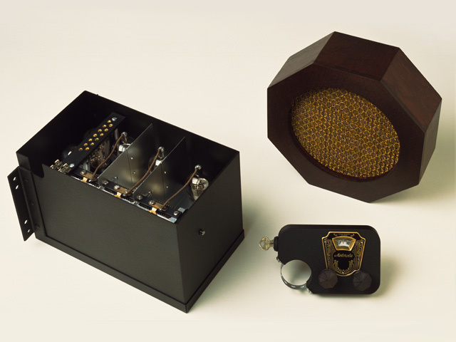
With today's money it will be somewhere around $ 2000, for the money in the 1930s it was possible to purchase half of a Ford T type car.
In 1932, the AS 5 receiver from Blaupunkt could be purchased for 465 Reichsmarks, which equaled approximately one third of the cost of a small car.
The first radio stations occupied about 10 liters of volume and did not fit into the dashboard. But next to the steering wheel was mounted control panel, so that the steering wheel radio control is not such a new invention. In 1933, autoradiols were already included in the package and installed at the factory.
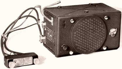
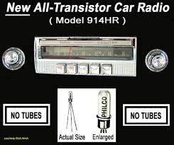
The time has passed, autoacoustics are constantly getting cheaper, until in the 1950s a new evolutionary leap occurred - radio receivers with the FM band appeared (before that, only AM), and in 1955 Chrysler introduced a fully transistor radio - Philco 914HR.
Until 1956 automusic entirely depended on radio waves and transmitters, until the same Chrysler offered the option to take the music with you to the car - on records! What happened with the needle and the tracks on the bumps, it is better, probably, not to know.

In 1964, tapes with a magnetic tape came onto the market, and a year later, Ford and Motorolla jointly launched a car stereo with a cassette player for Stereo 8. The speakers evolve and the stereo appears, and then the quad.
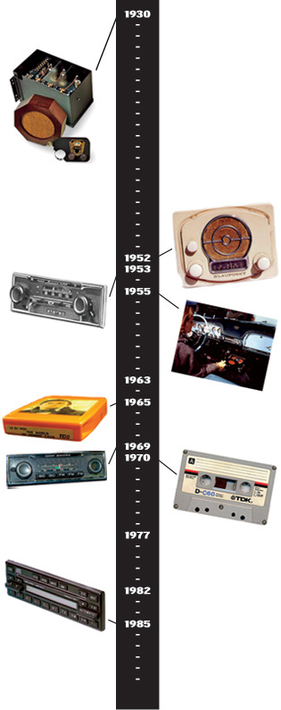
C 1982 At Pioneer, the first car stereo appears with a CD player.

And in the late 90s Empeg's already embedded MP3 player came out.
At this story the car audio ends and the present begins.
The second important need for a motorist is to know where you are and where to go. Car navigation began with paper maps in the glovebox. If you have doubts about the correctness of the chosen direction, you had to pull over, pull out and unfold a hefty map and for a long time figure out where you are with the car and where you end up in the end.
The most necessary and difficult place, naturally, turned out to be on the fold of the map. The “paved” route was remembered by the number of turns and not numerous road signs.
The oldest navigation system is considered to be the Jones Live-Map patented in 1909. She was a dial gauge connected to a car odometer.
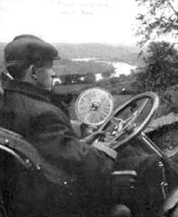
At the beginning of the journey, one of the paper discs was inserted that corresponded to the trip route.

The car began to move, the odometer to register the mileage, and the arrow on the navigation system jump from one path to another. One disk was enough for 100 miles, if the journey was further, you had to put the next disk.

The navigation system, however, could not understand and warn if the driver went astray or turned the wrong way. Errors simply accumulated and hints lost their meaning.
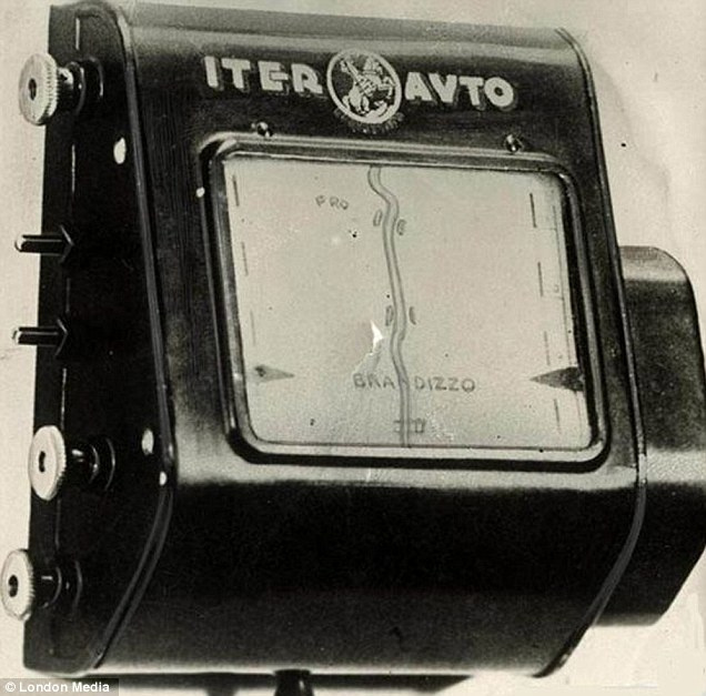
In the 1930s, the Iter Avto mechanical navigator was introduced with analog maps in the form of rolls with an automatic transport mechanism, also synchronized with a car odometer.
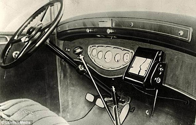
The rolls also changed depending on the route, and the map was automatically pulled along with the odometer.
Iter Avto released and compact wearable navigators:

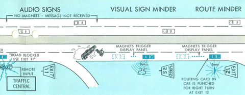
The next stage in the development of navigation occurred in 1966, when GM introduced the Driver Aid Information and Routing system (DAIR) system. DAIR was a real step forward and worked on punched cards, civilian radio signals (which would later be called CB) and external magnetic tags.
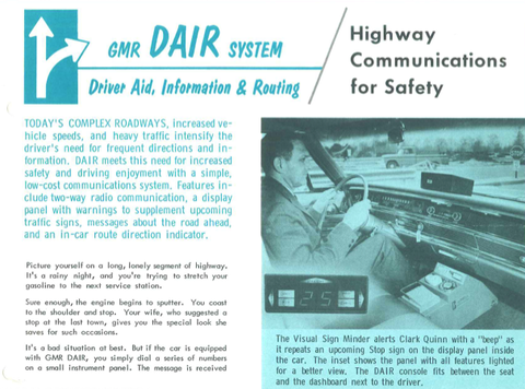
Magnets were installed under the roadway through a certain distance and before each intersection. A punch card with the desired route was inserted into the navigator panel, the system determined its position relative to the magnetic marks and showed on the display when the desired turn would be made. The magnets also encoded the allowed speed, and an over-warning warning flashed on the panel.
With the help of a dial-up disk, similar to a disk of old phones, it was possible to call for help, the police, the ambulance or the fire brigade on a coded radio channel. Signals about traffic events such as ceilings, accidents or repairs were transmitted by radio.
In 1956, GM went even further and introduced the concept of Highway of Tomorrow, where on special safe roads the driver could turn on the autopilot and transfer control of the car and route to a remote operator. The control was supposed to be carried out using a cable laid under the route. The first machine developed for this concept could be the gas turbine Firebird II.

Video, which tells the viewer from the 50s about the wonders of the future:
archive.org/details/Designfo1956
In 1981, the next breakthrough in navigation happens in Japan. As an additional option to the Accord, Honda offers the Electro Gyrocator system, which claims to be the first automatic navigation system to be commercially available.

She did not use satellite navigation, but relied entirely on the internal electronic gyroscope, which displayed the trip track on the screen. In addition to the gyroscope, a sensor was placed on the gearbox in order to more accurately take into account the driving mode and speed.
The data were displayed on a monochrome 6 '' CRT screen. Included with the system were translucent sheets with maps and a special marker. Sheets with maps were inserted in front of the screen and showed the driver a track of the path, their own POIs were entered into the navigation system with a special marker. The entire system weighed 9 kg and cost $ 2.746, or about a quarter of the cost of the machine itself.
Here is a video about how the system worked:
ETAK can rightfully be called the first mass fully electronic car navigation system in the world - it could be installed on any serial car and used electronic maps recorded on a compact cassette, electronic compass and wheel sensors for navigation.
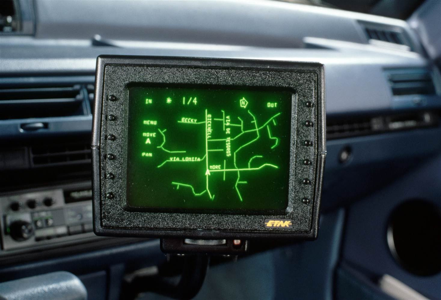
Yes, yes, that's right, no GPS, only “internal” navigation, while being fairly accurate. The data were displayed on a lowercase CRT display.
You can read more about this interesting project here .
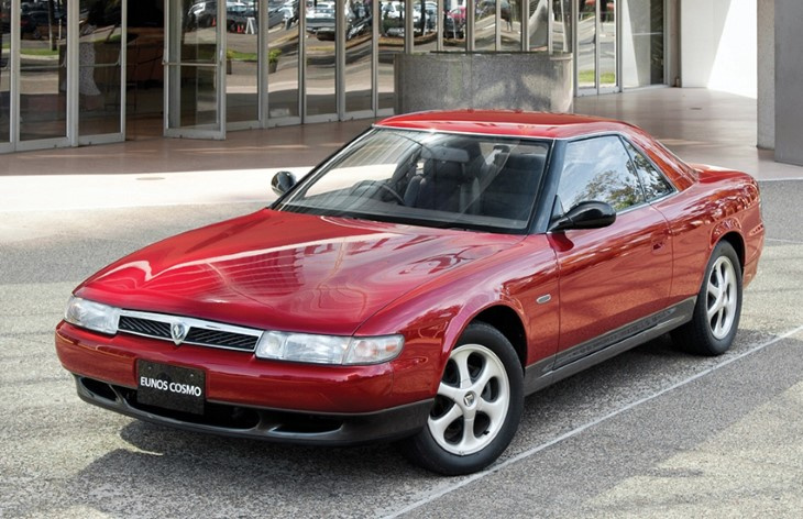
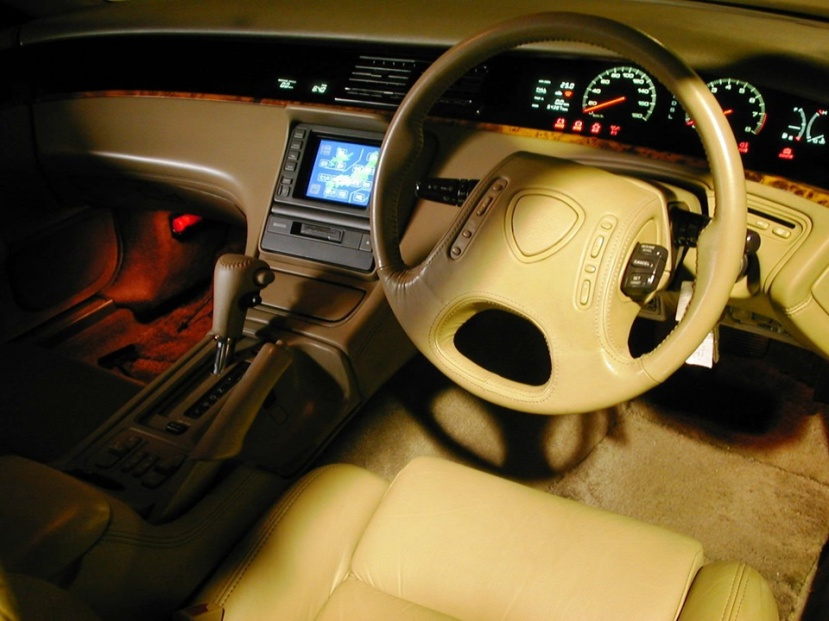
The first full-fledged GPS-navigators appeared in 1990, when Mazda released the first car with integrated GPS navigation - Eunos Cosmo. Then pulled Oldsmobile, Ford, BMW and other manufacturers.
But the main impetus for the dawn of GPS navigation was given in 2000, when the US government lifted restrictions on civilian GPS positioning from 100 meters to 5.
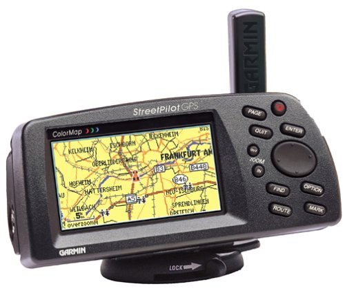
Automotive devices were divided into two branches, built-in (OEM) and external, which could be installed in any car:
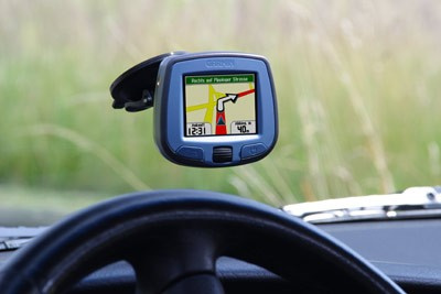
In Russia, until recently, the built-in navigation of almost every automaker (and moto too) had big problems with the Russian language, updating current maps and firmware. To the extent that people were forced to buy an additional removable car navigator and use it.
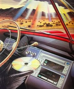
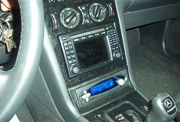
In modern times, two historical branches - music and navigation - come together and form a multifunctional automotive combine that can be found in many modern machines. Through the multimedia system, the driver was also able to control the vehicle’s on-board systems and manage telephone communications. Support for various data carriers, communication with a smartphone and many other functions today complement the simple driving. For the first time appeared such a thing as a car ecosystem.
This is an integrated digital environment of the car, combining many elements, including the mobile phone and its functions. The largest producers of mobile operating systems Apple and Google have developed their own standards for car ecosystems - Carplay and Android Auto, respectively. They allow the driver to control navigation, music, SMS, telephony and web search. To increase driving safety, systems support voice control.
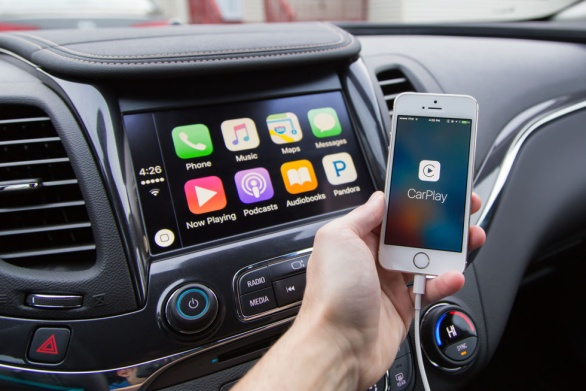

At the moment, the list of automakers and supported models is quite wide, moreover, many support both ecosystems at the same time.
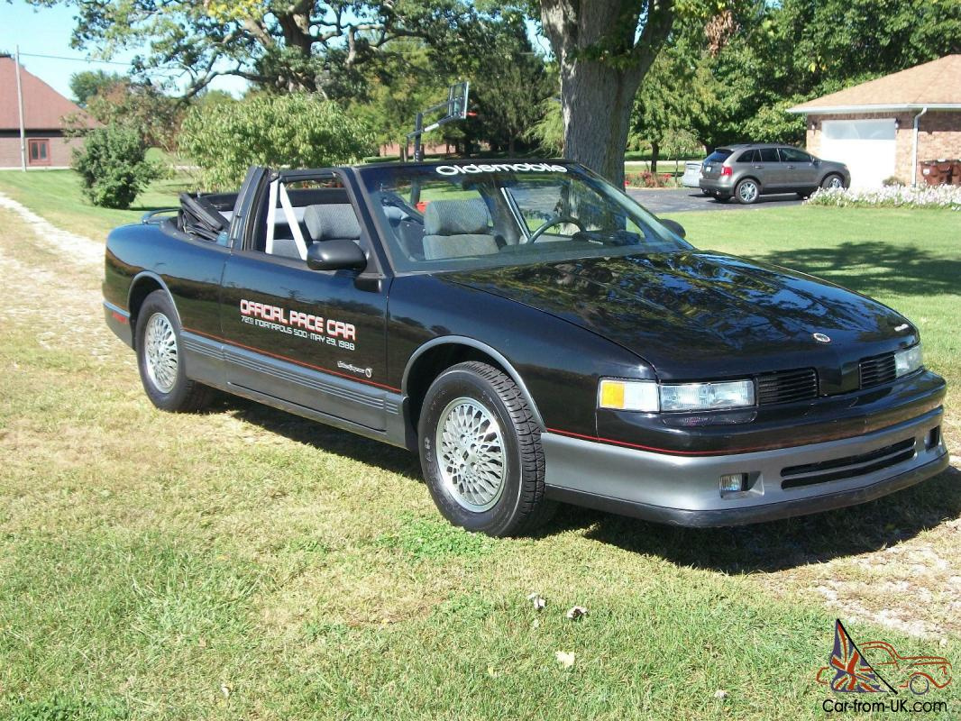
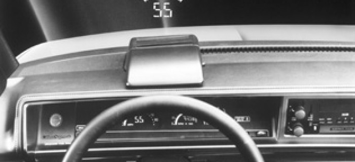
The first built-in projector was installed in 1988 in the Oldsmobile Cutlass Supreme Indianapolis 500 Pace Car. On the line of sight of the driver readings of an electronic speedometer were displayed. Japanese manufacturers Nissan and Toyota followed the market.
BMW calls itself the first European manufacturer of projection solutions. The first built-in projector appeared in 2004 in the ConnectedDrive system, which was installed in the 5th series.
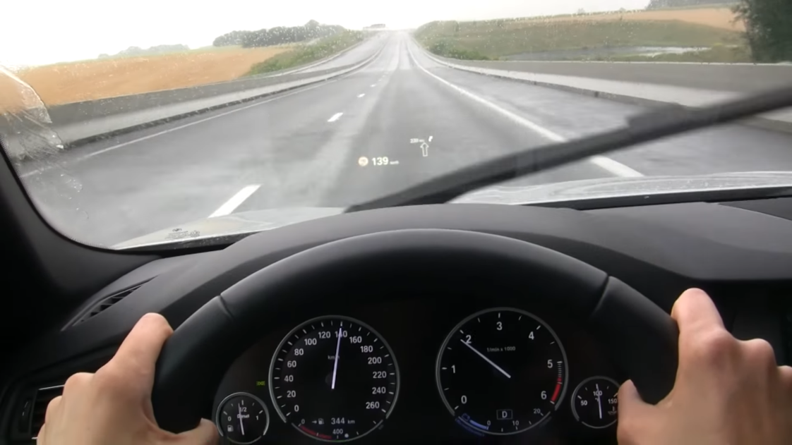
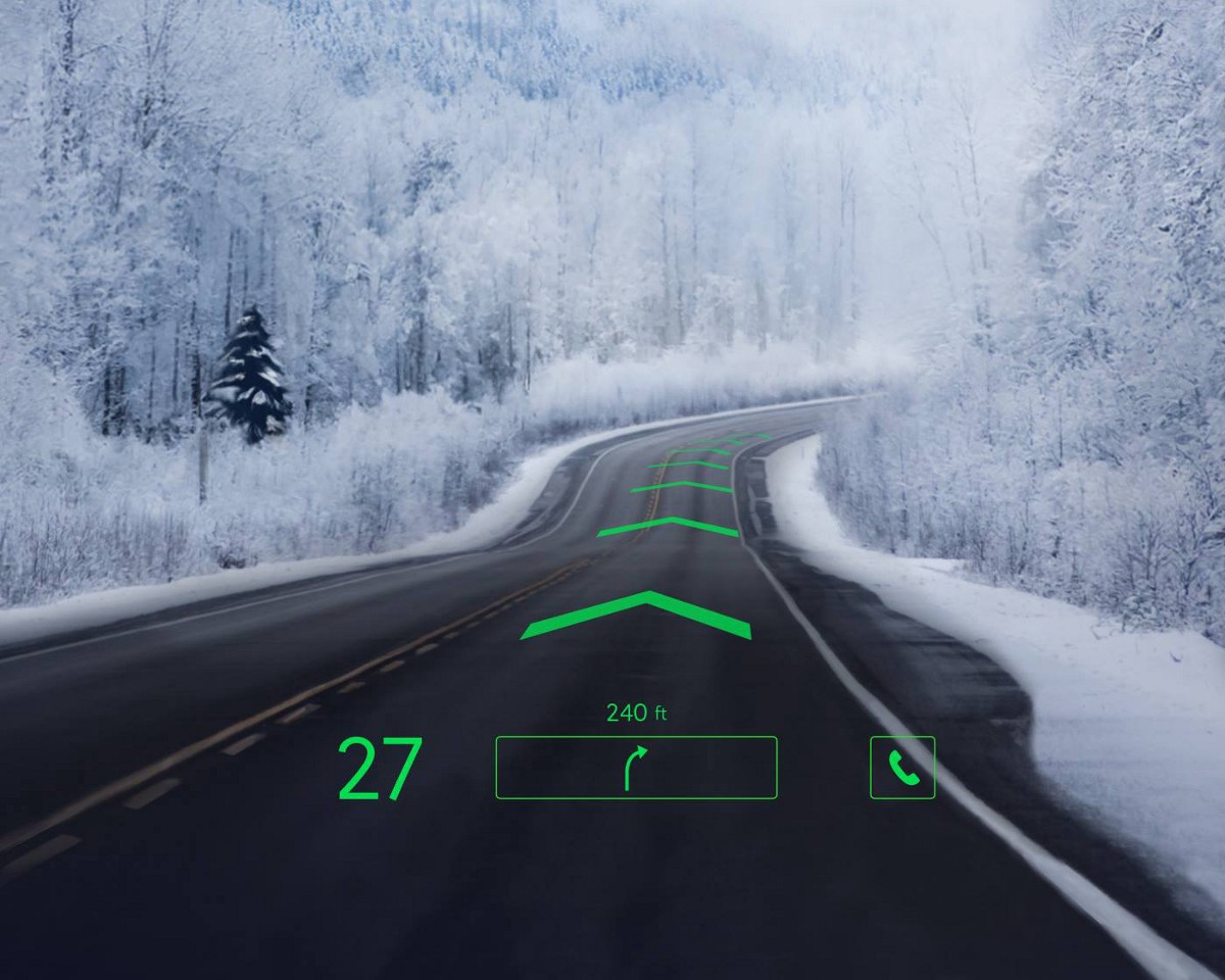
It was a small area on the windshield, where the current speed and navigation information in the form of arrows and distances were projected. At the moment, the manufacturer offers an improved version of the display. It became colored, tips on navigating difficult intersections, and information about road signs appeared.
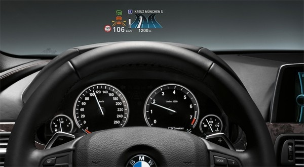
At the moment, almost all large auto companies offer HUD as options, mainly for business class cars. Their functionality is standard - duplication of vehicle instrumentation and navigation information with certain variations.
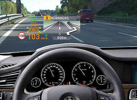
The disadvantages of such solutions are obvious - HUD is tied to only one specific model, and if you want to upgrade or expand functions, you will have to change the car entirely. The accuracy and completeness of the navigation prompts depends greatly on the quality of the cartographic information and its timely updating. In Russia, until recently, not all manufacturers have been doing well with it - the maps are old and rarely updated, and sometimes it is either impossible to update the multimedia center, or to give the car to the service. The advantages of such systems are full integration with the vehicle’s on-board electronics, from engine operating modes to controlling intelligent on-board systems, such as cruise control, FCWS (Forward Collision Warning) and car parking.
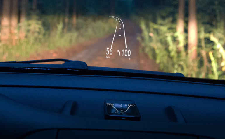
Compatibility problems lack universal displays, which you can purchase separately and install in any machine. There are a lot of offers on the market, prices for a set are also very different.
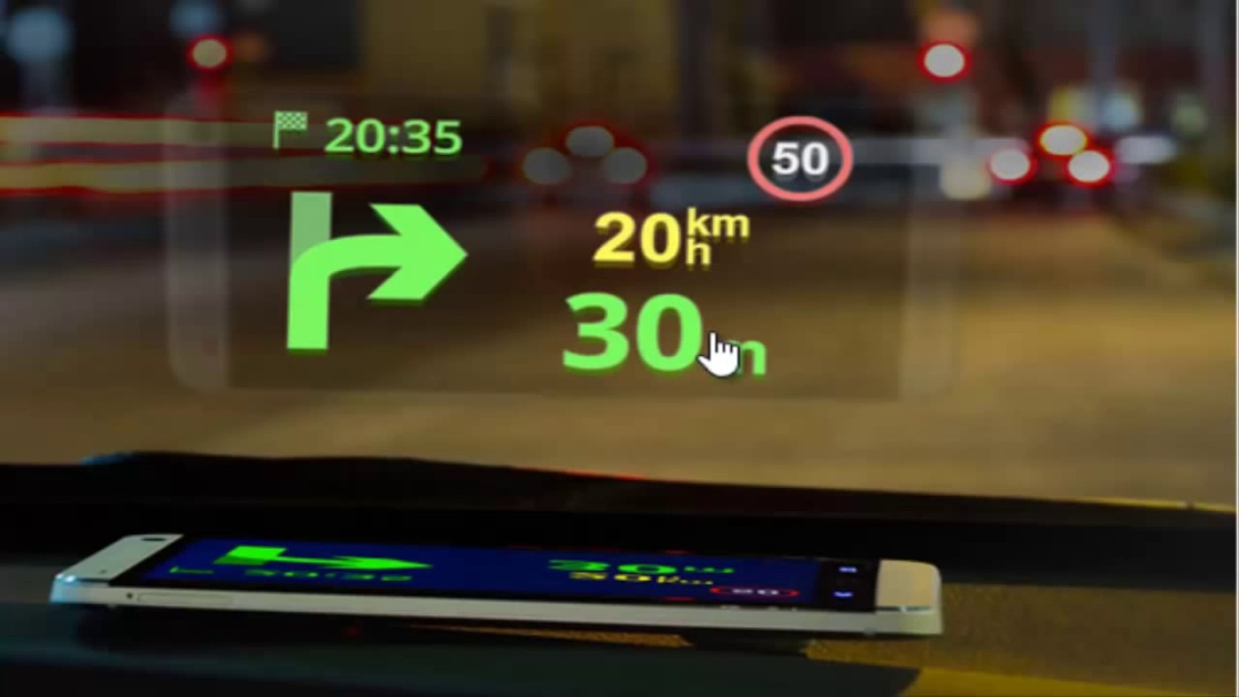
The cheapest option is to download a special application on your smartphone, which twists the brightness to the maximum and inverts the screen, and put the phone under the glass. For example, the Hudway app. The phone displays navigation tips and some movement parameters, such as speed using GPS.
Analog from Sygic:
Unfortunately, the cons significantly exceed the pros. During the daytime and in the bright light, the power of the backlight of the smartphone is categorically insufficient, the projections are simply not visible, the autoglasses of different manufacturers differ in the type of coating, and without a special reflective film, the image can be very divided. Some dashboards simply do not have a flat place on which the phone could hold.
Much better things with another project Hudway glass. Here you need to buy a special stand for your phone with a reflective screen, which will provide an acceptable image quality.

Thanks to a special reflector, the image is no longer doubled and can be better seen; the stand securely holds the phone and prevents it from jumping off. The disadvantages remain from the previous solution: small screen size, image problems in bright sunshine, there is no integration with car electronics.
Currently, individual projectors can be purchased on the market, which will display a much brighter and clearer picture either on projection glass or on a special film.
In addition to those already produced, there are several startup projects that only collect pre-orders. All these devices combine one thing, these are projection displays that are mounted on the car dashboard and project additional information either on the windshield or on a special reflective screen. None of these devices can work without a smartphone, its GPS and navigation functions. Often you need to download a specialized application.
Garmin:
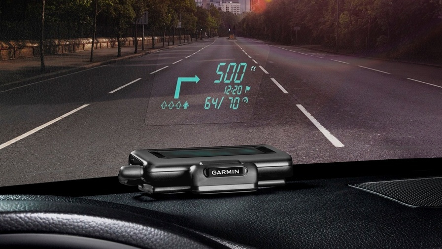
Pros : a simple, compact and inexpensive solution. You can stick a special film on the windshield from the kit or install a projection shield. It works even in bright sunlight.
Cons : sector screen can only project simple graphics, compatible with only one application, for the installation of which you need to pay extra money.
Navdy:
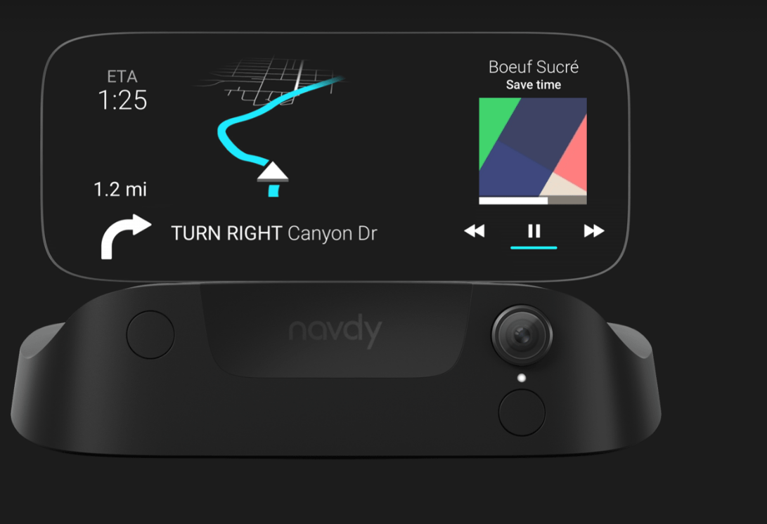
Navdy is quite a complex product. This is not just a projection screen; in addition to navigation, it understands voice commands and gestures, can receive calls and control music, OBDII communication allows broadcasting additional information from the on-board computer of the car to the screen.
The external projection display can be a good alternative to the built-in auto electronics, it is universal and suitable for most cars and smartphones, it is simply installed and configured. Depending on the complexity and functionality, you can choose a HUD for a different budget.
What can be expected from HUDs in the near future? First of all, this increase in image area, which will allow the driver to see and work with a large number of objects. Secondly, it is further facilitation of focusing the driver’s gaze from the road on the indicators and back. The third comes out of the first and second - a large interactive projection will allow you to create a full augmented reality and work with it! At first - only the windshield, then everything.
The closest thing to the above was the WayRay Navion concept, which will not only understand words and gestures, but also provide a complete augmented reality on the windshield of the car.
And the beginning of sales is just around the corner.
Therefore, it is logical that the first systems that came up with installation in cars were systems with entertainment and navigation. Further evolution led to the development of on-board control and diagnostics instruments and added communication functions. Significantly increased the amount of information received by the driver, and increased the complexity of its perception.
In this article, we will look at the evolution of car infotainment systems, ways of conveying information to the driver and try to imagine what awaits us in the near future.
Then
The most accessible and obvious entertainment in cars was music, and it appeared in the 1930s. You could get an excellent radio station from American Galvin Manufacturing Corporation. She was called Motorolla, and it was in her honor that the whole company was later renamed. The device cost 130 dollars.
With today's money it will be somewhere around $ 2000, for the money in the 1930s it was possible to purchase half of a Ford T type car.
In 1932, the AS 5 receiver from Blaupunkt could be purchased for 465 Reichsmarks, which equaled approximately one third of the cost of a small car.
The first radio stations occupied about 10 liters of volume and did not fit into the dashboard. But next to the steering wheel was mounted control panel, so that the steering wheel radio control is not such a new invention. In 1933, autoradiols were already included in the package and installed at the factory.
The time has passed, autoacoustics are constantly getting cheaper, until in the 1950s a new evolutionary leap occurred - radio receivers with the FM band appeared (before that, only AM), and in 1955 Chrysler introduced a fully transistor radio - Philco 914HR.
Until 1956 automusic entirely depended on radio waves and transmitters, until the same Chrysler offered the option to take the music with you to the car - on records! What happened with the needle and the tracks on the bumps, it is better, probably, not to know.
In 1964, tapes with a magnetic tape came onto the market, and a year later, Ford and Motorolla jointly launched a car stereo with a cassette player for Stereo 8. The speakers evolve and the stereo appears, and then the quad.
C 1982 At Pioneer, the first car stereo appears with a CD player.
And in the late 90s Empeg's already embedded MP3 player came out.
At this story the car audio ends and the present begins.
Navigation
The second important need for a motorist is to know where you are and where to go. Car navigation began with paper maps in the glovebox. If you have doubts about the correctness of the chosen direction, you had to pull over, pull out and unfold a hefty map and for a long time figure out where you are with the car and where you end up in the end.
The most necessary and difficult place, naturally, turned out to be on the fold of the map. The “paved” route was remembered by the number of turns and not numerous road signs.
The oldest navigation system is considered to be the Jones Live-Map patented in 1909. She was a dial gauge connected to a car odometer.
At the beginning of the journey, one of the paper discs was inserted that corresponded to the trip route.
The car began to move, the odometer to register the mileage, and the arrow on the navigation system jump from one path to another. One disk was enough for 100 miles, if the journey was further, you had to put the next disk.
The navigation system, however, could not understand and warn if the driver went astray or turned the wrong way. Errors simply accumulated and hints lost their meaning.
In the 1930s, the Iter Avto mechanical navigator was introduced with analog maps in the form of rolls with an automatic transport mechanism, also synchronized with a car odometer.
The rolls also changed depending on the route, and the map was automatically pulled along with the odometer.
Iter Avto released and compact wearable navigators:
The next stage in the development of navigation occurred in 1966, when GM introduced the Driver Aid Information and Routing system (DAIR) system. DAIR was a real step forward and worked on punched cards, civilian radio signals (which would later be called CB) and external magnetic tags.
Magnets were installed under the roadway through a certain distance and before each intersection. A punch card with the desired route was inserted into the navigator panel, the system determined its position relative to the magnetic marks and showed on the display when the desired turn would be made. The magnets also encoded the allowed speed, and an over-warning warning flashed on the panel.
With the help of a dial-up disk, similar to a disk of old phones, it was possible to call for help, the police, the ambulance or the fire brigade on a coded radio channel. Signals about traffic events such as ceilings, accidents or repairs were transmitted by radio.
In 1956, GM went even further and introduced the concept of Highway of Tomorrow, where on special safe roads the driver could turn on the autopilot and transfer control of the car and route to a remote operator. The control was supposed to be carried out using a cable laid under the route. The first machine developed for this concept could be the gas turbine Firebird II.
Video, which tells the viewer from the 50s about the wonders of the future:
archive.org/details/Designfo1956
In 1981, the next breakthrough in navigation happens in Japan. As an additional option to the Accord, Honda offers the Electro Gyrocator system, which claims to be the first automatic navigation system to be commercially available.
She did not use satellite navigation, but relied entirely on the internal electronic gyroscope, which displayed the trip track on the screen. In addition to the gyroscope, a sensor was placed on the gearbox in order to more accurately take into account the driving mode and speed.
The data were displayed on a monochrome 6 '' CRT screen. Included with the system were translucent sheets with maps and a special marker. Sheets with maps were inserted in front of the screen and showed the driver a track of the path, their own POIs were entered into the navigation system with a special marker. The entire system weighed 9 kg and cost $ 2.746, or about a quarter of the cost of the machine itself.
Here is a video about how the system worked:
ETAK can rightfully be called the first mass fully electronic car navigation system in the world - it could be installed on any serial car and used electronic maps recorded on a compact cassette, electronic compass and wheel sensors for navigation.
Yes, yes, that's right, no GPS, only “internal” navigation, while being fairly accurate. The data were displayed on a lowercase CRT display.
You can read more about this interesting project here .
The first full-fledged GPS-navigators appeared in 1990, when Mazda released the first car with integrated GPS navigation - Eunos Cosmo. Then pulled Oldsmobile, Ford, BMW and other manufacturers.
But the main impetus for the dawn of GPS navigation was given in 2000, when the US government lifted restrictions on civilian GPS positioning from 100 meters to 5.
Automotive devices were divided into two branches, built-in (OEM) and external, which could be installed in any car:
In Russia, until recently, the built-in navigation of almost every automaker (and moto too) had big problems with the Russian language, updating current maps and firmware. To the extent that people were forced to buy an additional removable car navigator and use it.
In modern times, two historical branches - music and navigation - come together and form a multifunctional automotive combine that can be found in many modern machines. Through the multimedia system, the driver was also able to control the vehicle’s on-board systems and manage telephone communications. Support for various data carriers, communication with a smartphone and many other functions today complement the simple driving. For the first time appeared such a thing as a car ecosystem.
This is an integrated digital environment of the car, combining many elements, including the mobile phone and its functions. The largest producers of mobile operating systems Apple and Google have developed their own standards for car ecosystems - Carplay and Android Auto, respectively. They allow the driver to control navigation, music, SMS, telephony and web search. To increase driving safety, systems support voice control.
At the moment, the list of automakers and supported models is quite wide, moreover, many support both ecosystems at the same time.
Projectors
The first built-in projector was installed in 1988 in the Oldsmobile Cutlass Supreme Indianapolis 500 Pace Car. On the line of sight of the driver readings of an electronic speedometer were displayed. Japanese manufacturers Nissan and Toyota followed the market.
BMW calls itself the first European manufacturer of projection solutions. The first built-in projector appeared in 2004 in the ConnectedDrive system, which was installed in the 5th series.
It was a small area on the windshield, where the current speed and navigation information in the form of arrows and distances were projected. At the moment, the manufacturer offers an improved version of the display. It became colored, tips on navigating difficult intersections, and information about road signs appeared.
At the moment, almost all large auto companies offer HUD as options, mainly for business class cars. Their functionality is standard - duplication of vehicle instrumentation and navigation information with certain variations.
The disadvantages of such solutions are obvious - HUD is tied to only one specific model, and if you want to upgrade or expand functions, you will have to change the car entirely. The accuracy and completeness of the navigation prompts depends greatly on the quality of the cartographic information and its timely updating. In Russia, until recently, not all manufacturers have been doing well with it - the maps are old and rarely updated, and sometimes it is either impossible to update the multimedia center, or to give the car to the service. The advantages of such systems are full integration with the vehicle’s on-board electronics, from engine operating modes to controlling intelligent on-board systems, such as cruise control, FCWS (Forward Collision Warning) and car parking.
Compatibility problems lack universal displays, which you can purchase separately and install in any machine. There are a lot of offers on the market, prices for a set are also very different.
The cheapest option is to download a special application on your smartphone, which twists the brightness to the maximum and inverts the screen, and put the phone under the glass. For example, the Hudway app. The phone displays navigation tips and some movement parameters, such as speed using GPS.
Analog from Sygic:
Unfortunately, the cons significantly exceed the pros. During the daytime and in the bright light, the power of the backlight of the smartphone is categorically insufficient, the projections are simply not visible, the autoglasses of different manufacturers differ in the type of coating, and without a special reflective film, the image can be very divided. Some dashboards simply do not have a flat place on which the phone could hold.
Much better things with another project Hudway glass. Here you need to buy a special stand for your phone with a reflective screen, which will provide an acceptable image quality.
Thanks to a special reflector, the image is no longer doubled and can be better seen; the stand securely holds the phone and prevents it from jumping off. The disadvantages remain from the previous solution: small screen size, image problems in bright sunshine, there is no integration with car electronics.
Currently, individual projectors can be purchased on the market, which will display a much brighter and clearer picture either on projection glass or on a special film.
In addition to those already produced, there are several startup projects that only collect pre-orders. All these devices combine one thing, these are projection displays that are mounted on the car dashboard and project additional information either on the windshield or on a special reflective screen. None of these devices can work without a smartphone, its GPS and navigation functions. Often you need to download a specialized application.
Garmin:
Pros : a simple, compact and inexpensive solution. You can stick a special film on the windshield from the kit or install a projection shield. It works even in bright sunlight.
Cons : sector screen can only project simple graphics, compatible with only one application, for the installation of which you need to pay extra money.
Navdy:
Navdy is quite a complex product. This is not just a projection screen; in addition to navigation, it understands voice commands and gestures, can receive calls and control music, OBDII communication allows broadcasting additional information from the on-board computer of the car to the screen.
The external projection display can be a good alternative to the built-in auto electronics, it is universal and suitable for most cars and smartphones, it is simply installed and configured. Depending on the complexity and functionality, you can choose a HUD for a different budget.
What can be expected from HUDs in the near future? First of all, this increase in image area, which will allow the driver to see and work with a large number of objects. Secondly, it is further facilitation of focusing the driver’s gaze from the road on the indicators and back. The third comes out of the first and second - a large interactive projection will allow you to create a full augmented reality and work with it! At first - only the windshield, then everything.
The closest thing to the above was the WayRay Navion concept, which will not only understand words and gestures, but also provide a complete augmented reality on the windshield of the car.
And the beginning of sales is just around the corner.
All Articles