Cosmic google for the planet?
The company Planet Labs announced the successful implementation of its main task, which was set at the foundation of the company. Mission 1, as they called it, was to launch a sufficient number of satellites to receive photographs of the entire surface of the Earth once a day. And now, when conditions are created on the side of space, information technologies come into play - a huge data stream will be available for analysis when solving a variety of tasks.
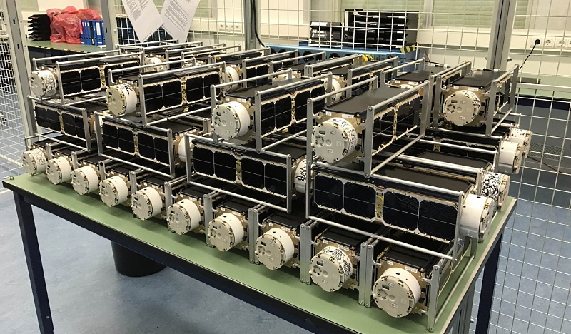
88 Dove / Flock 3p satellites before launch, photo by Planet Labs
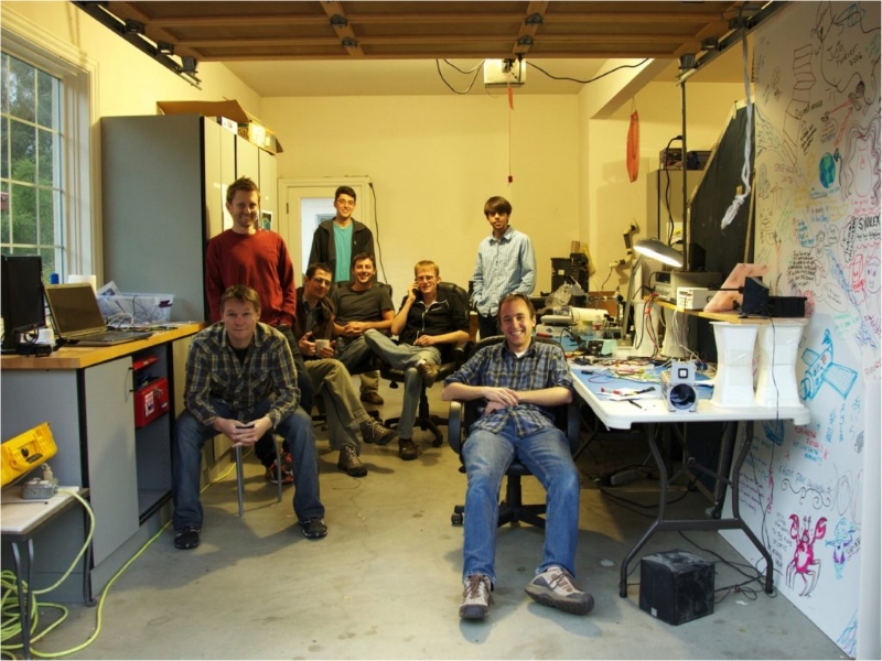
How it all began: the founder and seven employees in the garage, photos Planet Labs
The company Planet Labs, registered at the end of December 2010, managed to achieve a lot in a fairly short time. Their main idea was to launch a large number of cubes for continuous monitoring of the earth's surface. Small satellites can be easily added by fellow travelers to other vehicles, the accident of one launch vehicle will lead to the loss of only a small part of the grouping and acceptable losses, and the mass production of small vehicles allows them to be constantly upgraded. Thus was born Dove satellite ("Dove"). By the name of the devices, their groupings (and series) were called Flock ("Flock").
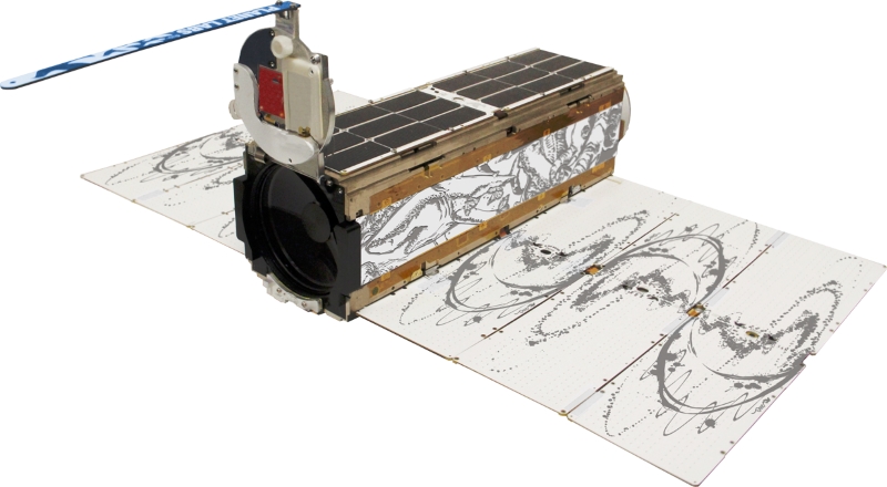
Satellite Dove, photo Planet Labs
In a cubic 3U (10x10x30 cm) weighing 4-5 kg they managed to place good optics and a control system - the spatial resolution of photos is 3-5 meters per pixel depending on the orbit. But the main thing is that Planet Labs bakes them like cakes, in series of several dozen devices. After four separate experimental satellites, the launches literally began to flow.
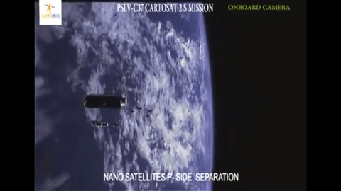
88 Flock satellites are separated from the dispenser, animation from the video of the Indian Space Agency
The intensity of launches from the ISS is explained by the fact that the satellites are slowed down by atmospheric residues at a relatively low orbit and live for 12-18 months, depending on solar activity. Satellites in polar orbit ~ 600 km will have to work for 4-5 years.
Things went so well with the company that in 2015 they absorbed BlackBridge, which created and launched RapidEye satellites, and in 2017 they bought Google Terra Bella with SkySat satellites that have a spatial resolution of less than a meter per pixel and a "chip" as an opportunity to shoot video.
Video of Mecca from space, pilgrims move around the Kaaba
But, going back to flocks of pigeons, why is the word “crawler” used in the title? The fact is that Planet Labs compare themselves with Google, their satellites constantly scan the Earth as Internet search robots.
In Stanislav Lem’s book “The Invincible”, they search for a landing on the planet and a missing starship and launch photo reconnaissance satellites, mobilize the crew to analyze photographs and find it quickly by chance, without noticing the most important feature of the planet. Analyzing manually one and a half million 29-megapixel images with a total size of 6 terabytes per day is depressing and pointless. And here computers and artificial intelligence come to the rescue.
In a day photos of 3/5 of the earth’s surface come from satellites. Another part can be closed by clouds, but in a week you can get photos of 95% of the Earth. The company has already established a data processing system in which the resulting photos are attached to the coordinates, slightly cleared and transferred to the machine learning platform. Work on it is just beginning, but the potential is fascinating. The resolution of 3-5 meters per pixel is enough to count the ships and containers in the port, and from this it is already possible to draw conclusions about the economic activity in the area. Here, for example, shooting port Botany in Australia with an interval of one day.
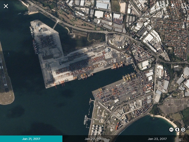
Animation of photos Planet Labs
From the growth of areas of solar panels in China, it is possible to calculate not only the growth of electricity produced by them, but by combining with photographs of other power plants, to obtain high-quality estimates of the country's energy system.

Animation Planet Labs
Some things are more visible from space than from the surface. Here, for example, illegal mines invade the territory of a natural reserve in Peru. Warnings Planet Labs reached the addressee - the Government of Peru drew attention to this area.
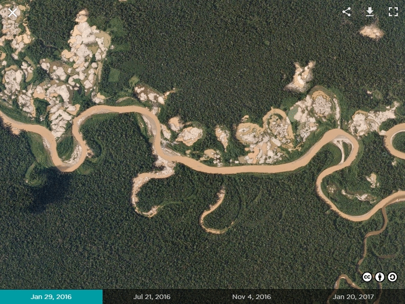
Animation of photos Planet Labs
Natural and man-made disasters can also be analyzed from space. Here is the animation of the accident and restoration work at the Oroville Dam this spring.
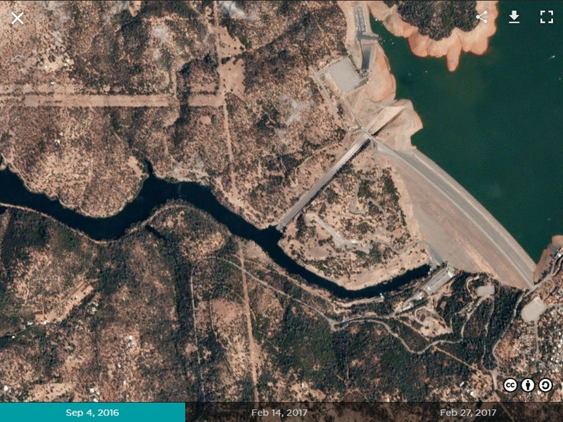
Animation of photos Planet Labs
In the gallery of the company's website you can see other examples.
Again, the platform for processing information received by satellites is still being developed and is the next important goal of Planet Labs. Things are even more fun - there is no understanding of what the combination of artificial intelligence and constantly replenished photos of the whole Earth will give. So far, the company's website is accepting applications from research teams, whose task will be trying to find a use for this. What is the effect of this idea? In its development, mankind does not play computer strategy and cannot look at the technology tree in order to know in advance the bonuses from a specific study. But, on the other hand, it is even more interesting.
88 Dove / Flock 3p satellites before launch, photo by Planet Labs
A pack of crawler
How it all began: the founder and seven employees in the garage, photos Planet Labs
The company Planet Labs, registered at the end of December 2010, managed to achieve a lot in a fairly short time. Their main idea was to launch a large number of cubes for continuous monitoring of the earth's surface. Small satellites can be easily added by fellow travelers to other vehicles, the accident of one launch vehicle will lead to the loss of only a small part of the grouping and acceptable losses, and the mass production of small vehicles allows them to be constantly upgraded. Thus was born Dove satellite ("Dove"). By the name of the devices, their groupings (and series) were called Flock ("Flock").
Satellite Dove, photo Planet Labs
In a cubic 3U (10x10x30 cm) weighing 4-5 kg they managed to place good optics and a control system - the spatial resolution of photos is 3-5 meters per pixel depending on the orbit. But the main thing is that Planet Labs bakes them like cakes, in series of several dozen devices. After four separate experimental satellites, the launches literally began to flow.
88 Flock satellites are separated from the dispenser, animation from the video of the Indian Space Agency
- 28 Flock 1 was delivered to the ISS in January 2014 by the Cygnus spacecraft and launched from the station (there is a special device on it to launch cube forces).
- 28 Flock 1b was brought to the ISS in the summer of 2014, 6 of them were not launched and returned to Earth.
- The same summer of 2014, together with other satellites on the Dnepr launch vehicle, launched 11 higher Flock 1c to a higher polar orbit.
- 26 Flock 1d died together with the cargo ship Cygnus in an accident in the autumn of 2014, after which 2 Flock 1d 'and 14 Flock 1e were delivered to the ISS.
- 8 Flock 1f were lost in the Falcon 9 accident in the summer of 2015.
- 14 Flock 2b was brought to the ISS by the HTV cargo ship in the summer of 2015, two of them did not start.
- 12 Flock 2e and 20 Flock 2e 'were delivered to the ISS at the end of 2015 and the beginning of 2016.
- 12 Flock 2p launched into the polar orbit on the Indian rocket PSLV-XL in the summer of 2016.
- 88 Flock 3p were launched into polar orbit in a record launch of 104 satellites by the Indian rocket PSLV-XL in spring 2017.
- 48 Flock 2k went to polar orbit in the summer of 2017 on a Soyuz rocket, setting a domestic record of 73 satellites in one launch.
- And finally, 4 Flock 3m were launched on October 31, 2017 at Minotaur-C.
The intensity of launches from the ISS is explained by the fact that the satellites are slowed down by atmospheric residues at a relatively low orbit and live for 12-18 months, depending on solar activity. Satellites in polar orbit ~ 600 km will have to work for 4-5 years.
Things went so well with the company that in 2015 they absorbed BlackBridge, which created and launched RapidEye satellites, and in 2017 they bought Google Terra Bella with SkySat satellites that have a spatial resolution of less than a meter per pixel and a "chip" as an opportunity to shoot video.
Video of Mecca from space, pilgrims move around the Kaaba
But, going back to flocks of pigeons, why is the word “crawler” used in the title? The fact is that Planet Labs compare themselves with Google, their satellites constantly scan the Earth as Internet search robots.
Data ex machina
In Stanislav Lem’s book “The Invincible”, they search for a landing on the planet and a missing starship and launch photo reconnaissance satellites, mobilize the crew to analyze photographs and find it quickly by chance, without noticing the most important feature of the planet. Analyzing manually one and a half million 29-megapixel images with a total size of 6 terabytes per day is depressing and pointless. And here computers and artificial intelligence come to the rescue.
In a day photos of 3/5 of the earth’s surface come from satellites. Another part can be closed by clouds, but in a week you can get photos of 95% of the Earth. The company has already established a data processing system in which the resulting photos are attached to the coordinates, slightly cleared and transferred to the machine learning platform. Work on it is just beginning, but the potential is fascinating. The resolution of 3-5 meters per pixel is enough to count the ships and containers in the port, and from this it is already possible to draw conclusions about the economic activity in the area. Here, for example, shooting port Botany in Australia with an interval of one day.
Animation of photos Planet Labs
From the growth of areas of solar panels in China, it is possible to calculate not only the growth of electricity produced by them, but by combining with photographs of other power plants, to obtain high-quality estimates of the country's energy system.
Animation Planet Labs
Some things are more visible from space than from the surface. Here, for example, illegal mines invade the territory of a natural reserve in Peru. Warnings Planet Labs reached the addressee - the Government of Peru drew attention to this area.
Animation of photos Planet Labs
Natural and man-made disasters can also be analyzed from space. Here is the animation of the accident and restoration work at the Oroville Dam this spring.
Animation of photos Planet Labs
In the gallery of the company's website you can see other examples.
Again, the platform for processing information received by satellites is still being developed and is the next important goal of Planet Labs. Things are even more fun - there is no understanding of what the combination of artificial intelligence and constantly replenished photos of the whole Earth will give. So far, the company's website is accepting applications from research teams, whose task will be trying to find a use for this. What is the effect of this idea? In its development, mankind does not play computer strategy and cannot look at the technology tree in order to know in advance the bonuses from a specific study. But, on the other hand, it is even more interesting.
All Articles