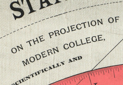
How did REN TV speak about the Earth flat, and Prokopenko “TEFI” received
On September 25, 2017, a program devoted to the flat-earth theory was broadcasted on the federal television channel REN TV, and already on October 3, Igor Prokopenko received the TEFI award for the Military Secret program in the Educational Program category. Considered the transfer refers to the cycle of programs of Igor Prokopenko "The most shocking hypotheses."
→ Program release on YouTube
Written here, of course, will not be a surprise for most readers, because The name of the channel itself has long become a meme, but still I decided to analyze this issue in detail, given that there are too many people who have succumbed in the 21st century to the influence of such a sect-like phenomenon as the flat earth theory for various reasons.
And it should be especially noted that the aggravation began long before the memes with the student.
Also, contrary to popular belief, most of the adepts of the flat earth theory are not trolls, everything is much sadder.
Before proceeding with a detailed analysis of this masterpiece, based on a comparison of information and my personal understanding of the topics under consideration, I suggest to get acquainted with the actors who will educate us throughout the program.
To begin, we will meet with Russian researchers invited to broadcast.
With the rest we will meet in the process.
According to REN TV:
In the real world:
Pavel Sviridov may indeed be a candidate of technical sciences. So, at least, it is written on his website, but there is no data on his scientific activities.
According to REN TV:
In the real world:
Unfortunately, nothing was found about the archaeological activity of Vadim. And in general there is very little information about this person in the network, but judging by his VK page, if she is not a fake, then he is apparently a fan of Diana Shurygina, as well as conspiracy.
According to REN TV:
In the real world:
I could not find evidence of Andrei’s activity as a popularizer of science. The main activity is astrology.
As you can see, the type of activity of these characters promises us complete competence, adequate assessment and quite logical reasoning in areas to which they are not related.
Splash.
Go!
0:43
The head of the mission Juno - Scott Bolton.
1:24
Former NASA employee, medicine man, carpenter, doctor, engineer, architect, and just comedian Matt Boylan.
In fact, the attitude of the person in the frame to NASA is known only from his words. There is no reliable evidence that he is a former NASA employee (at least I could not find any). But they managed to find performances as a stand-up comedian.
Also, according to information from the network, he also positions himself as a composer, chemist, herbal treatment consultant, engineer, architect, interior designer, carpenter, portrait painter, doctor, scientist, political expert and historian.
More like a summary of the regulars of some talk shows on our television, or a summary of the next "expert" from REN TV.
Accordingly, this part of the program about his revelations will not be considered in detail for lack of meaning.
3:10
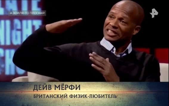
Dave Murphy. There is information that he began as a graphic designer, animator and programmer, and ends up as a conspiratorologist and landowner
He himself calls himself a former researcher (in a letter to Neil Degrass Tyson), but there is no relation to some scientific field in his biography. Yes, and an amateur physicist, this is probably the physicist who denies the existence of gravity, and does not understand how and why planes fly.
It is funny enough that in this program we are offered the opinion of some people, ostensibly from science. In fact, there is no information about their scientific activity. Nuuuu ... or the matrix blocked Google for me.
Two to four
I am not competent enough in ballistics, apparently, therefore I am not invited to REN TV as an expert, but the data found contradicts the statements in the program. Artillery apparently still sometimes takes into account the curvature of the Earth. This is noted in an English-language Wikipedia article. If for someone the article in Wikipedia is not a source that should be trusted, then similar information with regards to taking into account the curvature of the Earth is found in some other sources. You can also get acquainted with the data regarding the accounting for the rounding of the Earth in ballistics, for example, in this book starting from page 493:
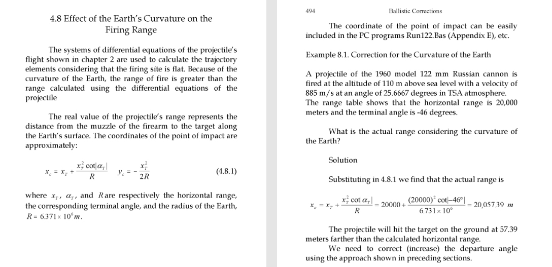
Screenshot from the book Exterior Ballistics
In general, as I understand it, this is an insignificant factor influencing accuracy, since There are more significant factors of influence.
5:33
It's a lie.
This manual from the official website of the US Marine Corps contains a description of the effects that affect, as well as tables of adjustments due to the rotation of the Earth:
http://www.marines.mil/Portals/59/Publications/mcwp3_16_4.pdf
It was also worth reading the "Basics of bombing" to the end, and not to tear the words out of context.
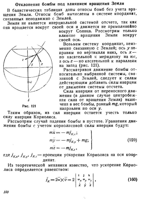
From page 180 begins a fascinating acquaintance with what is not according to the version of REN TV and the landowners.
5:53
Yes, it is relatively flat, except that the natural rounding of the Earth has not been canceled even on the salt marsh, but the evidence for the contrary in the program is not provided to us.
By the way, there is an article from the journal Nature telling that the salt-marsh is not so flat, although the differences in height are insignificant.
www.nature.com/news/2007/071130/full/news.2007.315.html
6:47
As you can see, the Earth is really flat, because the bases of the buildings are not visible. Although ... it is possible that part of the city is underwater.
We are not given any facts in favor of the reality of the distance of 140 km from which the survey was made; there is also no data about the height of the observer and weather conditions.
And it's not a fact that the shooting in the video of REN TV itself was generally positioned among the landowners.
But let's try to find these shots of Chicago from 140 km. What are we talking about? Googling, I came to the conclusion that I mean this photo. This was stated by a lonely post on Picaba (strangely, such an epic shot, worthy of mention on TV, but in fact a photo that someone so called).
Photos of Chicago allegedly from 140km. As we see the mirage is still present.
But, finding real data was not difficult. On the author's Facebook published time-lapses , which contains this frame.
The location is - Warren Dunes State Park.
Check the distance from there to the skyscrapers. It turns out something about 86 km. Ok let's round it up. Let it be 90 km.

There is a simulation of the appearance of Chicago on a spherical Earth, in which you can choose the distance, the height of the observer, etc., if you wish, you can also use refraction in the simulation (it is responsible for the mirage).
http://walter.bislins.ch/bloge/index.asp?page=Flat-Earth%3A+Finding+the+curvature+of+the+Earth
By the way, in the park from which the survey was conducted there are several rather high sand dunes, the highest of which reaches a height of 73 meters. In the description of the video, the author wrote that it was removed from the top of the dune (but not the fact that it was this one).
Highest point of Warren Dunes State Park.
So let's take it virtually and get it! And since we climbed high, and it’s not a fact that we shot from this dune, we will sacrifice a mirage and set a standard refraction.
We get this look:

Simulation of a city view (the height of the tallest tower in Chicago is taken into account), from a distance of 90 km, a height of 73 meters, with standard refraction and a lens focal length of 500mm (the larger, the larger the city). Right - spherical Earth. Left - flat.
As you can see, Chicago is quite possible to observe from such a distance on a spherical Earth with the help of optics (the author said that from the top of the dune, under the right weather conditions, everything is visible without the help of the camera). Moreover, we did not resort to strong refraction as in the photo, also the exact terrain relief was not taken into account, since buildings can be located on a hill. You can spin the simulation yourself, and “raise” the city even higher.
Perhaps, under special weather conditions, and even from a great height, it will be possible to see the tops of skyscrapers and from 140 km. But REN TV did not show us the shooting from 140 km, and the landowners, as far as I understood, “feed” with this very photo from 90km. And since we have no data for the simulation, we will not invent. And in general, the simulations came up with the Masons.
I completely forgot ...
ha ha ha
7:11
The rounding is seen from very high heights, but it is weakly expressed in the images. Simulation will help us to see this again. You can model the desired type of optics and height, thereby checking the rounding. Even on those shots where, at first glance, the horizon looks flat, in fact it is not.

Video arguments of land farmers from the Internet, when compressed in length, become convex. Of course, no one has canceled distortion, but to assert that the bulge is a plane is quite silly, especially considering that even without compression, the horizon sometimes does not look even in such videos.
Examples from the video from the Union and the stratospheric jump are also incorrect, since The optics used, and indeed the space that the Earth occupies in the frame, do not allow for a visual assessment of the rounding due to the large radius of the Earth. Moreover, on one of the frames of the video of a stratospheric jump, the Earth generally looks more concave than flat (an excellent course is to talk about distortions of optics and cite as an example frames and distortions, but inverse).
9:00
Apparently, this "scientist" is not aware that the Hubble telescope is not equipped with equipment that allows broadcasting live.
With regards to the impossibility of shooting the Earth with this telescope, there is an official application for all who are not particularly aware of the photographs and capabilities of various spacecraft.
hubblesite.org/reference_desk/faq/answer.php.id=78&cat=topten
The minimum exposure time of the Hubble telescope is 0.1 seconds. During this time, the telescope moves about 700 meters relative to the planet, respectively, all the images will be smeared. Obviously, such a shooting is completely inappropriate.
9:23
This is approximately in the same weight category of nonsense, as well as the surprise that the Moon taken from Earth to the camera of the phone does not look very impressive in contrast to shooting with long-focus lenses.
I think the operators of REN TV understand why this happens better than Murphy and the “scientists”, however, like every sensible person familiar with photo / video equipment. Accordingly, here too - sheer ignorance and incompetence on the part of the "scientist."
Just leave it here.
As an example, at 9:38 we are shown a snapshot of Lunar Orbiter 1, comparing it with a snapshot from the lunar surface and a snapshot from the circumlunar orbit.
Very well this effect is explained here .
10:03
Again, here is the complete incompetence of the archaeologist in this matter; it is no longer surprising. This effect is perfectly demonstrated in this video on the example of the globe, and depends on the same focal length and distance to the object.
Moreover, a fairly well-known photograph of the Earth , in which America visually occupies a larger area than we are used to seeing, is a composite image obtained from a distance that is quite close by cosmic standards. I will not consider it deeper, because REN TV did not show it to us.
11:27
Apparently, Igor Prokopenko is not from our planet because:
Igor Prokopenko says: “Where is the truth?” The truth is clearly not in his speech. Not to distinguish an asteroid from a meteorite is somehow quite weak for the owner of TEFI as the main enlightener of the country.
12:23
That same card.
This map is a polar azimuthal projection, namely, a sweep of a sphere with a north pole in the center. It has terrible distortions in the southern areas. You can estimate the distortion on a similar projection, but calculated having a south pole in the center instead of a north one on the map which Paul adheres to.

Polar azimuthal projection with a south pole in the center. Habitual territories of the northern hemisphere (in the real world) are distorted exactly the same way as the southern ones on the “landowners map”. The landowners from the southern hemisphere will obviously like it.
Both maps, of course, are real maps of the Earth, but none of them confirms the plane of our planet, just like a star-shaped map does not mean that our planet is in reality star-shaped, and evil Masonic Illuminati sinoists hide it .

Berghaus star projection
Unremarkable projection of this kind
It should be noted that the distortions on the same azimuthal projection, of course, disappear during the reverse projection onto the sphere.
Visual demonstration of azimuthal distortion.
In general, quite a disastrous opinion as a candidate of science, is not it?
12:36
J. Bush Sr., behind which a cosmonaut is visible on the screen against a checkered background.
As far as I know, for the first time this was discovered (although no one there found anything in the case, except for his own stupidity), foreign conspiracy therapists. But it is not so important.
Information persistently rubbed by us is not true, because this checkered background does not serve for the stated purposes, if not people from the TV channel are not aware of this.
This is a screen for experiences. Against its background, a series of experiments was recorded (unfortunately, Pavel did not find them), which are available to everyone, and as we can see without changing the background. Yes, the screen is used to fix the trajectories of objects, and in the end it turns out that.
One of the secret video
Video with water in zero gravity, this is a completely different video.
The statement at 14:17 about the experts and 100% coincidence in any way except as a blatant lie can not be called. If you see a 100% coincidence between these two videos, and you think that the second is the result of replacing the background and the ball, then congratulations, most likely you have big problems.
Based on the above facts, Pavel Sviridov brazenly lies.
All of Paul’s further comments on the subject of the ISS are about the same value.
16:18
As you know, the measure of the reliability of images in our time are RAW files. On this site you can find thousands of RAW files shot on the ISS by astronauts. Although ... stop ... most likely it is a fake, in the same place the Earth is rounded ... well, ok ... I'll leave a reference.
eol.jsc.nasa.gov/SearchPhotos
Further, consider the words of the archaeologist regarding the accuracy of the photo / video files do not see the point. He says that he does not understand.
4:30 pm
Frames may be for some reason, and in 1962, but we are talking about the Echo satellites. By the way, the satellites themselves were launched all the same on rockets, but they were already sulking in space.
18:10
In Brazil, not a satellite fell, but a stratostat for distributing the Internet project of Loon from Google. On it, even the inscription was CONTACT PROJECT LOON RECOVERY TEAM, apparently for such cases.
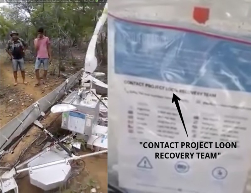
Fallen satellite and the inscription.
Link to the project website: x.company/loon
Wiki: ru.wikipedia.org/wiki/Project_Loon
The archaeologist again shows himself completely unprepared.
19:22
I cited the above link to the archive with the originals of the “rounding up” Earth (and not only) with the ISS.
20:10
Apparently, on Pikkar, the list of such physicists ends, and the archive is an English-language article on Wikipedia.
It is unlikely that Pikkar lied about the flat disk, because from a height of 17,000 m the curvature is insignificant (you can check in the same simulator that I mentioned above), the truth about the curved edges is not entirely clear, but we leave it on Pikkar’s conscience.
However, this does not make him a landowner, nor does he become more scientists who did not doubt the plane of the Earth.
21:48
Map of the Biblical Earth (in the real world). Map of what Orlando Ferguson saw (according to REN TV)
Comic enough. Especially considering that this is a map of the Biblical Earth, and, accordingly, is nothing more than a figment, however you should not be surprised, because in a conspiracy environment, it is customary to collect any trash and try to link it up with each other. But talking about religion is not the time.
22:00

Interestingly enough, they write in the article itself that the original of the map was devoured by worms, and what was mentioned above is not exactly what the Chinese supposedly drew.
Indeed, the Earth does not look like a ball, but like on all maps. But I could not find a snapshot of the original map; apparently, the worms still ate it, or the dog ate it.
22:22
Of course, the official criteria are interesting. The astrologer claims that they were sailed, traveled, used in navigation. Amazing facts, especially when you do not know what a cartographic projection is.
22:40
Gleason Map
In fact, the map itself is a map in the azimuthal projection already familiar to us. Apparently, the azimuthal projection is a priori a criterion for the plane in conspiracy therapists. I would like to look at the map on which the Earth is not flat, if we speak the language of REN TV.
We are persistently rubbed that travelers were guided by it. Yes, on a map that does not even have a scale. The scale below only shows the ratio of land and sea miles, as well as the correspondence of minutes and degrees of longitude to minutes of solar time.
It's funny enough that the map itself says that it uses a projection, and is not just a direct, undistorted display of the plane. It is a pity Alexander was ashamed to indicate the true type of projection.
Everything is even funnier perceived after reading the patent of this map www.google.ru/patents/US497917
23:13 The part that nobody has repeated the Cavendish experiment is completely incomprehensible.
But the values of the gravitational constant are periodically refined.

Source: Wikipedia
24:43 Fully we roll into frank game and start broadcasting about the dome.
25:35
In fact, we are shown, the trace after the launch of the rocket, then the clouds. But we have an astrologer and a landowner Paul, in whom these anomalies are caused by the malfunctioning of the dome.
Again, we do not get any proofs from the screen, or more or less adequate arguments. But for the audience waiting for the opening of the portal or repair the dome will come down. And to prove that these are consequences of rocket launches is tantamount to attempts to prove to a patient of a special institution that Comrade Stalin does not communicate with him through an outlet.
26:50
The view of the winter sky differs from the summer just in the configuration of the constellations (the configuration of the stars in them is unchanged). The Big Dipper, by the way, visually changes the inclination not only during the year, but also during the night due to the daily rotation of the Earth.
During the year, the view of the sky changes due to the rotation of the Earth around the Sun. In winter and summer, the Sun is visually located at opposite places on thedome of the celestial sphere, so in winter at night we see constellations that were not visible in summer, because opened to our gaze only during the day, but for obvious reasons we could not observe them. It is worth mentioning the undetected constellations. But ... here I am approaching Comrade Stalin and it is time to stop.
But the words about the change in the ratio of the angle with respect to the Sun, this is not the best explanation, in my opinion, from the candidate of sciences.
It would be better if we were told about the implementation of the sky in the theory of a flat Earth regarding the southern hemisphere and the southern constellations. Well, about the moon in a flat Earth model.
As you can see, the transfer itself, as well as the statements of experts, is becoming more and more fantasy and nonsense. But have to endure.
27:10
In fact, everything is easier.
In this talk, Hillary Clinton speaks of a “glass ceiling”, an expression meaning an obstacle that limits the career development of women, for reasons not related to their professional qualities.
Speaking of women, she said in general that she knew that they had not yet broken this high and durable "glass ceiling", but someday someone would be able to, and she hoped that it would happen soon.
Some people in the hall even laughed at this moment, perhaps because it sounded in two ways, but not because of Hillary’s secret knowledge, but because of raising his head in the hall where the performance took place (Jacob Javits Center) see it
28:43
In fact, the videos used are launches of amateur rockets, whose attitude towards landowners is as controversial as the attitude of the “experts” in this program to scientists. Here you can see with these rockets:
ddeville.com/rockets.htm
www.youtube.com/channel/UC2o0nOb-FvyvMkcsO9tYDAA
glory of science, even talked about de-backs, but to preserve the intrigue mentioned that not the fact that he was there was used.
29:55
The official explanation of the "researchers", of course, does not suit.
30:48
He himself invented, he himself refuted - the whole essence of cospyology.
32:00
Unfortunately, I did not encounter such information in order to judge the truth or falsity, and REN TV and the archaeologist do not give us exact data.
32:38
I advise experts to study:
ru.wikipedia.org/wiki/Oneteen-year_ cycle_solar_activity
33:09
On this topic, I managed to find the following data: the weight of a lunar spacesuit on Earth is 90kg. Leonov's spacesuit weight - 20 kg + knapsack 21 kg.
35:31 Again, the revelations of the "NASA employee." There is no point in looking at it.
36:03
And yes, the experiments on display cannot be iron proof of the Earth’s rotation, since they are held in artisanal conditions. In addition, there is indeed an element of a certain trick.
In general, in my opinion, it is even possible that the role of the Coriolis force in experiments of this scale is extremely small in comparison with other factors of influence. Among other things, laboratory studies of this kind were also conducted, the recordings of which were included in a series of educational films on hydromechanics.
Vorticity (1 of 2)
Vorticity (2 of 2)
web.mit.edu/hml/ncfmf/09VOR.pdf
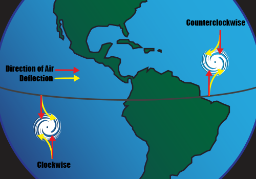
Yes, and with regard to the twisting of something in different hemispheres due to the rotation of the Earth is worth mentioning the larger-scale twists, namely the rotation of atmospheric eddies in different hemispheres.
Next comes a very boring part about Antarctica, full of water and the conjectures of the plan “he himself invented, he himself refuted”, not supported by any more or less serious arguments, so I’ll consider it partially and superficially.
40:22
I didn’t see Antarctica from the Martian surface, only from the near-Martian orbit (and then in the quality, because of which such image in conspiracy therapists immediately fall into the category of "fake"), but google "Satellite imagery of Antarctica" to "researchers" I advise ... although what I am talking about ... there are no pictures of “researchers” that coincide with the worldview, and accordingly, what is a real snapshot automatically becomes graphics. Again I suffer a fiasco.
40:45
Apparently ... we will have to accept.
www.jpl.nasa.gov/spaceimages/details.php?id=PIA00117
43:27
I did not know that astronauts make such discoveries. So it seems that the conditional screenwriter says: “Astronomer ... astronaut ... what the fuck is the difference? Well this is REN TV! ”
45:18
Thanks Igor!
Despite the fact that we did not want to be misled, for 45 minutes we were told about things related to astronomy, physics, astronautics and cartography, two astrologers, one archaeologist, comedian, medicine man andamateur physicist programmer.
It is clear that this is not news and common practice for REN TV, when in their programs there are things like when a false scientist or a mechanic-writer fiction tells about particle physics, and how they affect the density of the chair on Thursdays.
Yes, this is the content level of REN TV, which I tried to show with a concrete example in as much detail as I had the patience (you can continue indefinitely).
Unfortunately, this is a federal TV channel. And this flow of truth is not controlled in any way, and besides, it is encouraged, including the TEFI awards.
I thank those who stood up to the end.
→ Program release on YouTube
Written here, of course, will not be a surprise for most readers, because The name of the channel itself has long become a meme, but still I decided to analyze this issue in detail, given that there are too many people who have succumbed in the 21st century to the influence of such a sect-like phenomenon as the flat earth theory for various reasons.
And it should be especially noted that the aggravation began long before the memes with the student.
Also, contrary to popular belief, most of the adepts of the flat earth theory are not trolls, everything is much sadder.
Before proceeding with a detailed analysis of this masterpiece, based on a comparison of information and my personal understanding of the topics under consideration, I suggest to get acquainted with the actors who will educate us throughout the program.
To begin, we will meet with Russian researchers invited to broadcast.
With the rest we will meet in the process.
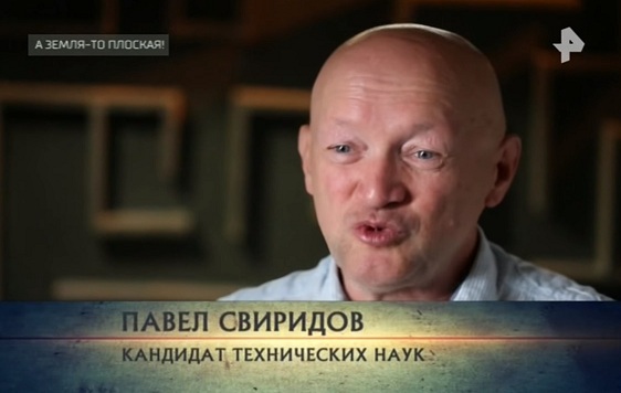
1. Pavel Sviridov
According to REN TV:
- Scientist / Candidate of Technical Sciences
In the real world:
- An astrologer, a landowner, a conspiracy theorist (also, possibly, a candidate of technical and legal sciences and a colonel).
Pavel Sviridov may indeed be a candidate of technical sciences. So, at least, it is written on his website, but there is no data on his scientific activities.
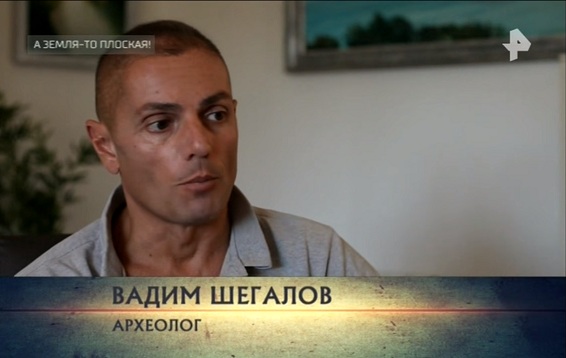
2. Vadim Shegalov
According to REN TV:
- Archaeologist / Scientist
In the real world:
- ???
Unfortunately, nothing was found about the archaeological activity of Vadim. And in general there is very little information about this person in the network, but judging by his VK page, if she is not a fake, then he is apparently a fan of Diana Shurygina, as well as conspiracy.
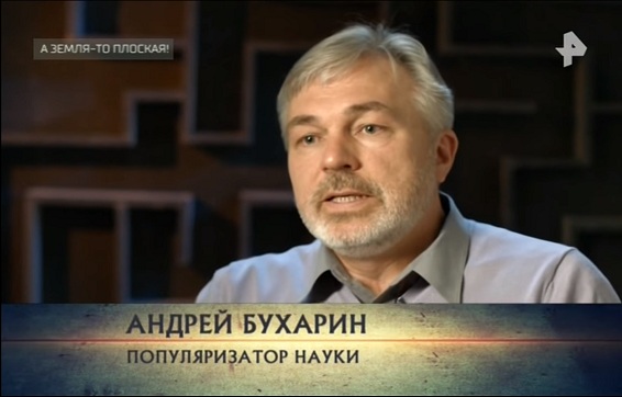
3. Andrei Bukharin
According to REN TV:
- Popularizer of
falsescience
In the real world:
- Astrologer
I could not find evidence of Andrei’s activity as a popularizer of science. The main activity is astrology.
As you can see, the type of activity of these characters promises us complete competence, adequate assessment and quite logical reasoning in areas to which they are not related.
About time codes
I warn you in advance that time codes may not be accurate, and some things may not be considered, because an endless stream of delirium of truth was doing its job, or something too sounded meaningless to refute or even consider it in general.
Splash.
Go!
0:43
The voiceover speaks of the shocking revelation of a NASA employee! The video series also shows us the current head of the mission Juno - Scott Bolton, but this is not the worst.
The head of the mission Juno - Scott Bolton.
1:24
We are shown an ancient, mysterious video on which, as we are trying to convey, is a former NASA employee named Matthew Boylan who was forced to make a spherical image from a flat Earth.
Former NASA employee, medicine man, carpenter, doctor, engineer, architect, and just comedian Matt Boylan.
In fact, the attitude of the person in the frame to NASA is known only from his words. There is no reliable evidence that he is a former NASA employee (at least I could not find any). But they managed to find performances as a stand-up comedian.
Also, according to information from the network, he also positions himself as a composer, chemist, herbal treatment consultant, engineer, architect, interior designer, carpenter, portrait painter, doctor, scientist, political expert and historian.
More like a summary of the regulars of some talk shows on our television, or a summary of the next "expert" from REN TV.
Accordingly, this part of the program about his revelations will not be considered in detail for lack of meaning.
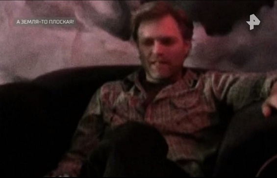
3:10
From this point on, a person in the frame named David Murphy will be referred to as a scientist, although the title says that he is supposedly just an amateur physicist.
Dave Murphy. There is information that he began as a graphic designer, animator and programmer, and ends up as a conspiratorologist and landowner
He himself calls himself a former researcher (in a letter to Neil Degrass Tyson), but there is no relation to some scientific field in his biography. Yes, and an amateur physicist, this is probably the physicist who denies the existence of gravity, and does not understand how and why planes fly.
It is funny enough that in this program we are offered the opinion of some people, ostensibly from science. In fact, there is no information about their scientific activity. Nuuuu ... or the matrix blocked Google for me.
Two to four
We are told that the artillery does not take into account the curvature of the Earth
I am not competent enough in ballistics, apparently, therefore I am not invited to REN TV as an expert, but the data found contradicts the statements in the program. Artillery apparently still sometimes takes into account the curvature of the Earth. This is noted in an English-language Wikipedia article. If for someone the article in Wikipedia is not a source that should be trusted, then similar information with regards to taking into account the curvature of the Earth is found in some other sources. You can also get acquainted with the data regarding the accounting for the rounding of the Earth in ballistics, for example, in this book starting from page 493:
Screenshot from the book Exterior Ballistics
In general, as I understand it, this is an insignificant factor influencing accuracy, since There are more significant factors of influence.
5:33
It is said that some scientists (apparently our actors) explain that all calculations on the ballistics of bombing are done taking into account the fact that the Earth is flat and stationary.
It's a lie.
This manual from the official website of the US Marine Corps contains a description of the effects that affect, as well as tables of adjustments due to the rotation of the Earth:
http://www.marines.mil/Portals/59/Publications/mcwp3_16_4.pdf
It was also worth reading the "Basics of bombing" to the end, and not to tear the words out of context.
From page 180 begins a fascinating acquaintance with what is not according to the version of REN TV and the landowners.
5:53
The archaeologist says that he was on the Uyuni salt marsh and saw that at least there the Earth was flat.
Yes, it is relatively flat, except that the natural rounding of the Earth has not been canceled even on the salt marsh, but the evidence for the contrary in the program is not provided to us.
By the way, there is an article from the journal Nature telling that the salt-marsh is not so flat, although the differences in height are insignificant.
www.nature.com/news/2007/071130/full/news.2007.315.html
6:47
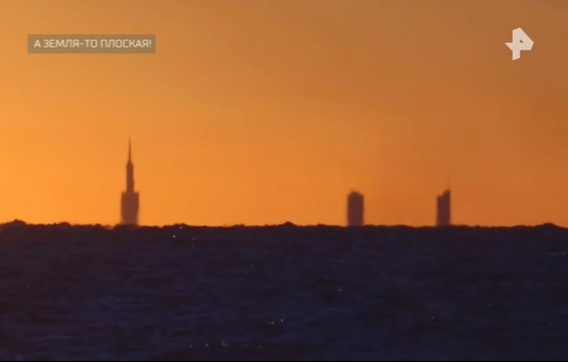
This is about Chicago, which is visible from a distance of 140 km, and should have dropped 1.5 kilometers beyond the horizon due to the curvature of the Earth. The man with the caption "Science Popularizer" is in fact again an astrologer and thus, apparently, does not popularize science, but pseudoscience. Sits and laughs at a mirage. But he laughs best who laughs last. In addition, the video series perfectly demonstrates how the lower part of the skyscrapers disappeared beyond the horizon is clearly not out of the plane of the Earth. Well done here though.
As you can see, the Earth is really flat, because the bases of the buildings are not visible. Although ... it is possible that part of the city is underwater.
We are not given any facts in favor of the reality of the distance of 140 km from which the survey was made; there is also no data about the height of the observer and weather conditions.
And it's not a fact that the shooting in the video of REN TV itself was generally positioned among the landowners.
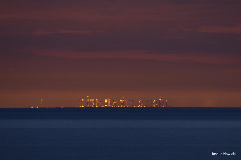
But let's try to find these shots of Chicago from 140 km. What are we talking about? Googling, I came to the conclusion that I mean this photo. This was stated by a lonely post on Picaba (strangely, such an epic shot, worthy of mention on TV, but in fact a photo that someone so called).
Photos of Chicago allegedly from 140km. As we see the mirage is still present.
But, finding real data was not difficult. On the author's Facebook published time-lapses , which contains this frame.
The location is - Warren Dunes State Park.
Check the distance from there to the skyscrapers. It turns out something about 86 km. Ok let's round it up. Let it be 90 km.
There is a simulation of the appearance of Chicago on a spherical Earth, in which you can choose the distance, the height of the observer, etc., if you wish, you can also use refraction in the simulation (it is responsible for the mirage).
http://walter.bislins.ch/bloge/index.asp?page=Flat-Earth%3A+Finding+the+curvature+of+the+Earth
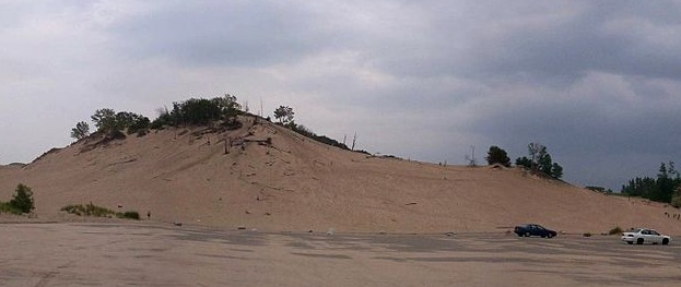
By the way, in the park from which the survey was conducted there are several rather high sand dunes, the highest of which reaches a height of 73 meters. In the description of the video, the author wrote that it was removed from the top of the dune (but not the fact that it was this one).
Highest point of Warren Dunes State Park.
So let's take it virtually and get it! And since we climbed high, and it’s not a fact that we shot from this dune, we will sacrifice a mirage and set a standard refraction.
We get this look:
Simulation of a city view (the height of the tallest tower in Chicago is taken into account), from a distance of 90 km, a height of 73 meters, with standard refraction and a lens focal length of 500mm (the larger, the larger the city). Right - spherical Earth. Left - flat.
As you can see, Chicago is quite possible to observe from such a distance on a spherical Earth with the help of optics (the author said that from the top of the dune, under the right weather conditions, everything is visible without the help of the camera). Moreover, we did not resort to strong refraction as in the photo, also the exact terrain relief was not taken into account, since buildings can be located on a hill. You can spin the simulation yourself, and “raise” the city even higher.
Perhaps, under special weather conditions, and even from a great height, it will be possible to see the tops of skyscrapers and from 140 km. But REN TV did not show us the shooting from 140 km, and the landowners, as far as I understood, “feed” with this very photo from 90km. And since we have no data for the simulation, we will not invent. And in general, the simulations came up with the Masons.
I completely forgot ...
ha ha ha
7:11
It is a question of the curvature in the pictures due to the special imaging equipment.
Further! ARCHAEOLOGIST! talks about photography, a fisheye lens, and that with a conventional lens you will never see any curvature.
The rounding is seen from very high heights, but it is weakly expressed in the images. Simulation will help us to see this again. You can model the desired type of optics and height, thereby checking the rounding. Even on those shots where, at first glance, the horizon looks flat, in fact it is not.
Video arguments of land farmers from the Internet, when compressed in length, become convex. Of course, no one has canceled distortion, but to assert that the bulge is a plane is quite silly, especially considering that even without compression, the horizon sometimes does not look even in such videos.
Examples from the video from the Union and the stratospheric jump are also incorrect, since The optics used, and indeed the space that the Earth occupies in the frame, do not allow for a visual assessment of the rounding due to the large radius of the Earth. Moreover, on one of the frames of the video of a stratospheric jump, the Earth generally looks more concave than flat (an excellent course is to talk about distortions of optics and cite as an example frames and distortions, but inverse).
9:00
"The scientist" Dave Murphy calls on NASA to show Earth live using the Hubble telescope.
Apparently, this "scientist" is not aware that the Hubble telescope is not equipped with equipment that allows broadcasting live.
With regards to the impossibility of shooting the Earth with this telescope, there is an official application for all who are not particularly aware of the photographs and capabilities of various spacecraft.
hubblesite.org/reference_desk/faq/answer.php.id=78&cat=topten
The minimum exposure time of the Hubble telescope is 0.1 seconds. During this time, the telescope moves about 700 meters relative to the planet, respectively, all the images will be smeared. Obviously, such a shooting is completely inappropriate.
9:23
Murphy through the mouth of the TV channel REN TV talks about the different proportions of the Earth from the Moon in NASA images. The following is an example of various images.
This is approximately in the same weight category of nonsense, as well as the surprise that the Moon taken from Earth to the camera of the phone does not look very impressive in contrast to shooting with long-focus lenses.
I think the operators of REN TV understand why this happens better than Murphy and the “scientists”, however, like every sensible person familiar with photo / video equipment. Accordingly, here too - sheer ignorance and incompetence on the part of the "scientist."
Just leave it here.
As an example, at 9:38 we are shown a snapshot of Lunar Orbiter 1, comparing it with a snapshot from the lunar surface and a snapshot from the circumlunar orbit.
Very well this effect is explained here .
10:03
For some reason, the archaeologist again assumes the responsibility to talk about photographic equipment, but although he says the right things about orbits and focal lengths, these explanations do not suit him, because apparently do not coincide with his worldview. He also cites the example of differences in the proportions of the continents in some pictures of the Earth from space.
Again, here is the complete incompetence of the archaeologist in this matter; it is no longer surprising. This effect is perfectly demonstrated in this video on the example of the globe, and depends on the same focal length and distance to the object.
Moreover, a fairly well-known photograph of the Earth , in which America visually occupies a larger area than we are used to seeing, is a composite image obtained from a distance that is quite close by cosmic standards. I will not consider it deeper, because REN TV did not show it to us.
11:27
Igor Prokopenko says that astronomers warn that a meteorite the size of the Earth’s floor is flying towards our planet.
Apparently, Igor Prokopenko is not from our planet because:
- Meteorite is already a fallen body.
- Astronomers did not warn about this, because meteorite does not fly.
Igor Prokopenko says: “Where is the truth?” The truth is clearly not in his speech. Not to distinguish an asteroid from a meteorite is somehow quite weak for the owner of TEFI as the main enlightener of the country.
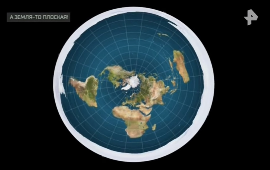
12:23
The astrologer / candidate of technical sciences Pavel Sviridov, according to REN TV, assures that the Earth is flat and its real map looks like it is shown at 12:32.
That same card.
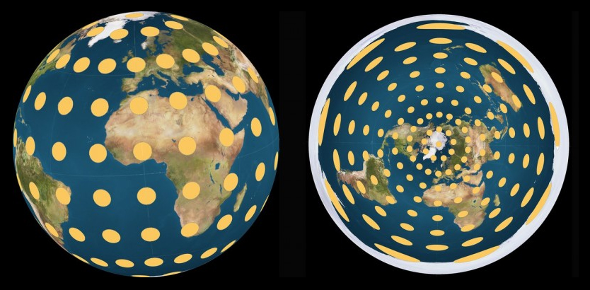
This map is a polar azimuthal projection, namely, a sweep of a sphere with a north pole in the center. It has terrible distortions in the southern areas. You can estimate the distortion on a similar projection, but calculated having a south pole in the center instead of a north one on the map which Paul adheres to.
Polar azimuthal projection with a south pole in the center. Habitual territories of the northern hemisphere (in the real world) are distorted exactly the same way as the southern ones on the “landowners map”. The landowners from the southern hemisphere will obviously like it.
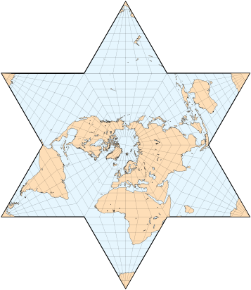
Both maps, of course, are real maps of the Earth, but none of them confirms the plane of our planet, just like a star-shaped map does not mean that our planet is in reality star-shaped, and evil Masonic Illuminati sinoists hide it .
Berghaus star projection
Unremarkable projection of this kind
It should be noted that the distortions on the same azimuthal projection, of course, disappear during the reverse projection onto the sphere.
Visual demonstration of azimuthal distortion.
In general, quite a disastrous opinion as a candidate of science, is not it?
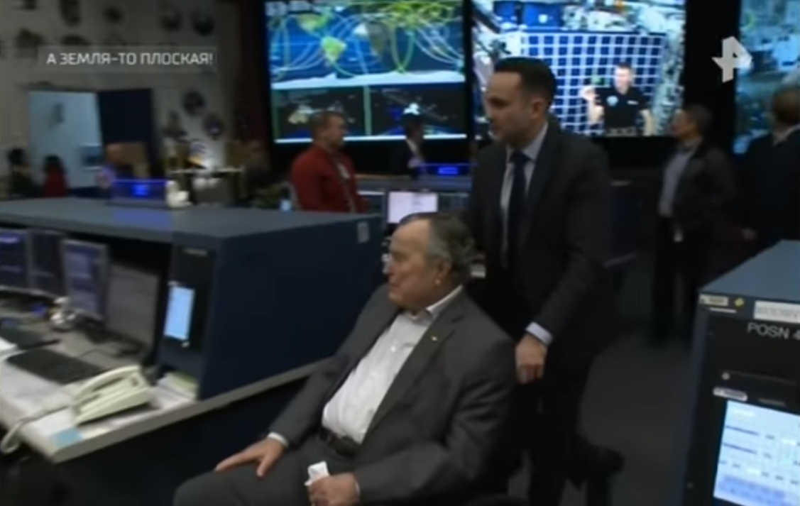
12:36
The connection between the map and the hypothesis of Paul is not clear. The following is a video of Bush elder in a wheelchair and an astronaut against the background of “used in the film industry.” We are told that Pavel Sviridov discovered this feature.
J. Bush Sr., behind which a cosmonaut is visible on the screen against a checkered background.
As far as I know, for the first time this was discovered (although no one there found anything in the case, except for his own stupidity), foreign conspiracy therapists. But it is not so important.
Information persistently rubbed by us is not true, because this checkered background does not serve for the stated purposes, if not people from the TV channel are not aware of this.
This is a screen for experiences. Against its background, a series of experiments was recorded (unfortunately, Pavel did not find them), which are available to everyone, and as we can see without changing the background. Yes, the screen is used to fix the trajectories of objects, and in the end it turns out that.
One of the secret video
Video with water in zero gravity, this is a completely different video.
The statement at 14:17 about the experts and 100% coincidence in any way except as a blatant lie can not be called. If you see a 100% coincidence between these two videos, and you think that the second is the result of replacing the background and the ball, then congratulations, most likely you have big problems.
Based on the above facts, Pavel Sviridov brazenly lies.
All of Paul’s further comments on the subject of the ISS are about the same value.
16:18
For some reason, the archaeologist again plays the role of a person who judges the authenticity of something based on his own perception. In this case, about the authenticity of images from the ISS.
As you know, the measure of the reliability of images in our time are RAW files. On this site you can find thousands of RAW files shot on the ISS by astronauts. Although ... stop ... most likely it is a fake, in the same place the Earth is rounded ... well, ok ... I'll leave a reference.
eol.jsc.nasa.gov/SearchPhotos
Further, consider the words of the archaeologist regarding the accuracy of the photo / video files do not see the point. He says that he does not understand.
4:30 pm
We are shown unique frames with satellite-balloons, which miraculously rose to a height of 4 times the orbit of the ISS and so on.
Frames may be for some reason, and in 1962, but we are talking about the Echo satellites. By the way, the satellites themselves were launched all the same on rockets, but they were already sulking in space.
18:10
The same archaeologist says about the fall of the satellite on a balloon in Brazil.
In Brazil, not a satellite fell, but a stratostat for distributing the Internet project of Loon from Google. On it, even the inscription was CONTACT PROJECT LOON RECOVERY TEAM, apparently for such cases.
Fallen satellite and the inscription.
Link to the project website: x.company/loon
Wiki: ru.wikipedia.org/wiki/Project_Loon
The archaeologist again shows himself completely unprepared.
19:22
The archaeologist says that perhaps they (the space organizations) do not have originals.
I cited the above link to the archive with the originals of the “rounding up” Earth (and not only) with the ISS.
20:10
The archaeologist says that even in the 20th century it was possible to find world-famous physicists who did not doubt that the Earth was flat. As an example, we are quoted by Auguste Piccard that, from a height of 17,000 meters, the Earth seemed to be a flat disk with curved edges. The archaeologist read this in the archives.
Apparently, on Pikkar, the list of such physicists ends, and the archive is an English-language article on Wikipedia.
It is unlikely that Pikkar lied about the flat disk, because from a height of 17,000 m the curvature is insignificant (you can check in the same simulator that I mentioned above), the truth about the curved edges is not entirely clear, but we leave it on Pikkar’s conscience.
However, this does not make him a landowner, nor does he become more scientists who did not doubt the plane of the Earth.
21:48
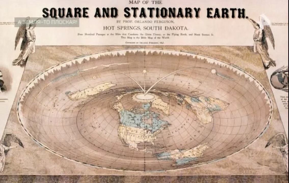
We are shown a map of Orlando Ferguson, saying that this is what Piccard saw. Quote! "The earth on it is flat, with curved edges."
Map of the Biblical Earth (in the real world). Map of what Orlando Ferguson saw (according to REN TV)
Comic enough. Especially considering that this is a map of the Biblical Earth, and, accordingly, is nothing more than a figment, however you should not be surprised, because in a conspiracy environment, it is customary to collect any trash and try to link it up with each other. But talking about religion is not the time.
22:00
Then we are shown, apparently, a very serious and reliable source with a Chinese map of the world, made allegedly 10 centuries ago. We are told that the Earth on this map ... is again flat.
Interestingly enough, they write in the article itself that the original of the map was devoured by worms, and what was mentioned above is not exactly what the Chinese supposedly drew.
Indeed, the Earth does not look like a ball, but like on all maps. But I could not find a snapshot of the original map; apparently, the worms still ate it, or the dog ate it.
22:22
The popularizer ofastrology and falsescience tells us about the maps of the USA of the 19th century, where? hemispheric? Earth is the official map of the world.
Of course, the official criteria are interesting. The astrologer claims that they were sailed, traveled, used in navigation. Amazing facts, especially when you do not know what a cartographic projection is.
22:40
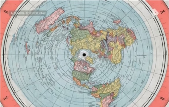
And here it is, the map of Alexander Gleason, and again the voice-over voice says that the Earth is flat on it (how do they do it?).
Gleason Map
In fact, the map itself is a map in the azimuthal projection already familiar to us. Apparently, the azimuthal projection is a priori a criterion for the plane in conspiracy therapists. I would like to look at the map on which the Earth is not flat, if we speak the language of REN TV.
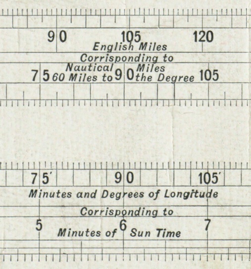
We are persistently rubbed that travelers were guided by it. Yes, on a map that does not even have a scale. The scale below only shows the ratio of land and sea miles, as well as the correspondence of minutes and degrees of longitude to minutes of solar time.
It's funny enough that the map itself says that it uses a projection, and is not just a direct, undistorted display of the plane. It is a pity Alexander was ashamed to indicate the true type of projection.
Everything is even funnier perceived after reading the patent of this map www.google.ru/patents/US497917
23:13 The part that nobody has repeated the Cavendish experiment is completely incomprehensible.
But the values of the gravitational constant are periodically refined.
Source: Wikipedia
24:43 Fully we roll into frank game and start broadcasting about the dome.
25:35
We are told about the frightening phenomenon of thenatives. The key phrase from the speaker: "It is impossible to explain this from the point of view of science, scientists say," and so on.
In fact, we are shown, the trace after the launch of the rocket, then the clouds. But we have an astrologer and a landowner Paul, in whom these anomalies are caused by the malfunctioning of the dome.
Sometimes it happens
More recently, in the circles of adepts of alternative science and other flat-spiricology, there was a panic over the test launch of an intercontinental ballistic missile RS-12M Topol from the Kapustin Yar test site.

Judging by this, malfunctions in the work of the dome by the landowners periodically occur, respectively, such opinions are not surprising. But not from the screen of the federal TV channel?
Judging by this, malfunctions in the work of the dome by the landowners periodically occur, respectively, such opinions are not surprising. But not from the screen of the federal TV channel?
Again, we do not get any proofs from the screen, or more or less adequate arguments. But for the audience waiting for the opening of the portal or repair the dome will come down. And to prove that these are consequences of rocket launches is tantamount to attempts to prove to a patient of a special institution that Comrade Stalin does not communicate with him through an outlet.
26:50
, .
, , — « , … ». , - .
The view of the winter sky differs from the summer just in the configuration of the constellations (the configuration of the stars in them is unchanged). The Big Dipper, by the way, visually changes the inclination not only during the year, but also during the night due to the daily rotation of the Earth.
During the year, the view of the sky changes due to the rotation of the Earth around the Sun. In winter and summer, the Sun is visually located at opposite places on the
But the words about the change in the ratio of the angle with respect to the Sun, this is not the best explanation, in my opinion, from the candidate of sciences.
It would be better if we were told about the implementation of the sky in the theory of a flat Earth regarding the southern hemisphere and the southern constellations. Well, about the moon in a flat Earth model.
As you can see, the transfer itself, as well as the statements of experts, is becoming more and more fantasy and nonsense. But have to endure.
27:10
. . ., , , . , «» 28:02 , (, )
In fact, everything is easier.
In this talk, Hillary Clinton speaks of a “glass ceiling”, an expression meaning an obstacle that limits the career development of women, for reasons not related to their professional qualities.
Speaking of women, she said in general that she knew that they had not yet broken this high and durable "glass ceiling", but someday someone would be able to, and she hoped that it would happen soon.
Some people in the hall even laughed at this moment, perhaps because it sounded in two ways, but not because of Hillary’s secret knowledge, but because of raising his head in the hall where the performance took place (Jacob Javits Center) see it
28:43
We are told about the problem in the form of rockets. How do they cope with the dome, and if they cope at all? Then we are shown the launch of an amateurish rocket (according to REN TV, by Western landowners). At 28:54, there is a video insert with the launch of a rocket by land plots.
In fact, the videos used are launches of amateur rockets, whose attitude towards landowners is as controversial as the attitude of the “experts” in this program to scientists. Here you can see with these rockets:
ddeville.com/rockets.htm
www.youtube.com/channel/UC2o0nOb-FvyvMkcsO9tYDAA
glory of science, even talked about de-backs, but to preserve the intrigue mentioned that not the fact that he was there was used.
29:55
Amazing The rocket does not fly vertically!
The official explanation of the "researchers", of course, does not suit.
30:48
One YouTube figure is surprised that computer graphics are being marketed as computer graphics, but it seems to him that he was deceived.
He himself invented, he himself refuted - the whole essence of cospyology.
32:00
The archaeologist says a statement from a NASA employee regarding the Van Allen belt is not yet overcome.
Unfortunately, I did not encounter such information in order to judge the truth or falsity, and REN TV and the archaeologist do not give us exact data.
32:38
We are told about NASA’s assurances that the astronauts went to the moon during the Solar Minimum (although we are not told what kind of flight we are talking about), but some independent experts claim that it is impossible to predict this even for the next 24 hours.
I advise experts to study:
ru.wikipedia.org/wiki/Oneteen-year_ cycle_solar_activity
33:09
Reflections on the weight of spacesuits. They talk about astronauts' light suits and Leonov's heavy spacesuit.
On this topic, I managed to find the following data: the weight of a lunar spacesuit on Earth is 90kg. Leonov's spacesuit weight - 20 kg + knapsack 21 kg.
35:31 Again, the revelations of the "NASA employee." There is no point in looking at it.
36:03
They talk about experiments with water twisting in different hemispheres due to Coriolis force, which confirm that the Earth rotates, but Maxim Belyaev says that the experiments are not correct.
And yes, the experiments on display cannot be iron proof of the Earth’s rotation, since they are held in artisanal conditions. In addition, there is indeed an element of a certain trick.
In general, in my opinion, it is even possible that the role of the Coriolis force in experiments of this scale is extremely small in comparison with other factors of influence. Among other things, laboratory studies of this kind were also conducted, the recordings of which were included in a series of educational films on hydromechanics.
Vorticity (1 of 2)
Vorticity (2 of 2)
web.mit.edu/hml/ncfmf/09VOR.pdf
Yes, and with regard to the twisting of something in different hemispheres due to the rotation of the Earth is worth mentioning the larger-scale twists, namely the rotation of atmospheric eddies in different hemispheres.
Next comes a very boring part about Antarctica, full of water and the conjectures of the plan “he himself invented, he himself refuted”, not supported by any more or less serious arguments, so I’ll consider it partially and superficially.
40:22
"Researchers" say that in open access there is not a single image of Antarctica from space. Exist only from the Moon and the Martian surface.
I didn’t see Antarctica from the Martian surface, only from the near-Martian orbit (and then in the quality, because of which such image in conspiracy therapists immediately fall into the category of "fake"), but google "Satellite imagery of Antarctica" to "researchers" I advise ... although what I am talking about ... there are no pictures of “researchers” that coincide with the worldview, and accordingly, what is a real snapshot automatically becomes graphics. Again I suffer a fiasco.
40:45
The archaeologist says that in the public domain you will not find anything.
Apparently ... we will have to accept.
www.jpl.nasa.gov/spaceimages/details.php?id=PIA00117
43:27
We are told that in 2017, a group of astronauts reported the discovery of flat planets.
I did not know that astronauts make such discoveries. So it seems that the conditional screenwriter says: “Astronomer ... astronaut ... what the fuck is the difference? Well this is REN TV! ”
45:18
Igor Prokopenko asks not to be offended, and says that they did not want to mislead us.
Thanks Igor!
Despite the fact that we did not want to be misled, for 45 minutes we were told about things related to astronomy, physics, astronautics and cartography, two astrologers, one archaeologist, comedian, medicine man and
It is clear that this is not news and common practice for REN TV, when in their programs there are things like when a false scientist or a mechanic-writer fiction tells about particle physics, and how they affect the density of the chair on Thursdays.
Yes, this is the content level of REN TV, which I tried to show with a concrete example in as much detail as I had the patience (you can continue indefinitely).
Unfortunately, this is a federal TV channel. And this flow of truth is not controlled in any way, and besides, it is encouraged, including the TEFI awards.
PS
Perhaps my psyche received damage in the process of viewing, and I misled you.
I thank those who stood up to the end.
All Articles